"DATLUN" (c)
"Virtual Moon Atlas" (VMA)
databases manager
Documentation for version available on October 1st, 2006
Welcome in "DATLUN" (c) the "Virtual Moon Atlas" databases manager.
As amateur astronomers, we continue to improve VMA for conceiving a useful software for lunar observer also efficient "on the field". We try to add new functions and a user friendly interface. This is why we have included in this new "Pro" version of "VMA", a database manager called "DATLUN" (copyrighted name) that allows you to select precisely lunar formations that seems you interesting for your own studies and that allows you to localize them on the VMA map.
This first version includes the functions that have seemed us the more useful. Sure, we are yet thinking to new possibilities that will be included in the next versions.
"DATLUN" is a dedicated to the Moon software which is very powerful since it uses SQL requests. This manual is nécessary to discover all its possibilities. We advice you to read it carefully while testing the described functions.
Good use and we haope that you will appreciate this new software and recommand it around you.
Thank you very much for your confidence.
Christian Legrand & Patrick Chevalley
DATLUN SCREEN
DATLUN screen is in a Windows frame. As all the Windows frames, you can minimize, maximize or adapt its size if you click on the upper right buttons in the title bar.
It's possible to open together VMA and DATLUN allowing formations localisation on the map, while accessing to all the datas about thes formations..
DATLUN window features :
- The menus bar
- The window "List"
- The state bar
THE MENUS BAR
![]()
This bar contains the menus giving access to functions lists.
THE "FILES" MENU
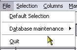
As a tradition in all Windows (r) sofwares, in DATLUN it's used
to select and maintain the databases and to exit the software.
"Default selection" FUNCTION
This function allows you to come back to the maximum selection which is the "default" selection. All the databases and all the columns are selected and there is no SQL request running in background.
"Database maintenance" FUNCTION
This function conducts to a new sub-menu :
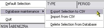
"Export selection to CSV" function
This function allows you to export the selected formations list which is visible in the "List" window into a CSV file usable in the major calc softwares as Microsoft Excel (r)
The classic Windows "record files" window will appear. Record your extraction in the directory you have choosen.
Beware, databases informations are copyrighted and can be used only for personal use and not in a commercial goal.
"Import selection from CSV" function
This function allows you to import a personal formations list compiled in a CSV file and import it as a VMA database.
Please, have a look at the detailed description here to see how it works.
"Delete selection from database" function
BE CAREFUL WHEN USING THIS FUNCTION !
If you click on this function, the selesction realized in "DATLUN"
will be immediatly deleted from the involved databases and cannot be recovered,
but if you reinstall VMA Pro.
"Quit" FUNCTION
This function allows you to quit "DATLUN" and closes all the databases. The setup about selected databases, columns and selection will be kept for your next session.
This menu opens a window which permits you :
- to select the databases to be used.
- to select formations types that you want to study.
- to select a formations list based on a specific value in a single field.
- to select a formations list based on several crossed criterias.
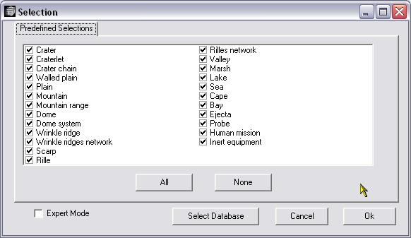
On first time, the window opens in "basic" mode. After
that, it's possible to use the "Expert" mode.
"Select databases" function
When pressing the "Select database" button opens a new window :
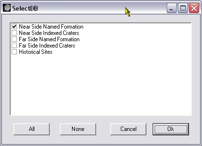
Fill boxes of all the dtabases you want to open. The more opened, the more longer for managing them. If your computer is not too powerful, select useful minimum.
It's, sure, necessary to have downloaded and / or installed these databases before. New databases are on work and could be incorporated in VMA and DATLUN in the future.
"Named" is about formations named as Aristarchus or Vallis Alpes.
"Indexed" is about craters with a name followed by a letter as Lambert R ou Hesiodus A.
"Historical sites" is about impacts or landings sites of human or automatic missions.
The "All" button select all the bases in a single operation and the button "None" is for the reversed operation.
Click on the "OK" button when your selection is done. This window disappears and you come back to the Formations type selection window.
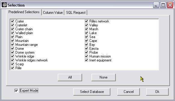
"Predefined selections" THUMBNAIL
Fill boxes of all the formations types that you want to select. The more selected, the more longer for managing them. If your computer is not too powerful, select useful minimum.
The "All" button select all the types in a single operation and the button "None" is for the reversed operation.
"Expert" mode
If you fill the "Expert" mode box, two new thumbnails appear.
"Column value" THUMBNAIL
When you click on this thumbnail, you can select all the formations that incorporate the EXACT value that you specify in the field that you have choosen.
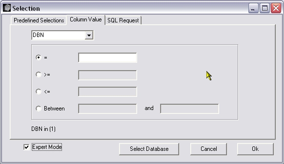
The upper scrolling list allows you to choose the column.
Then fill the bow corresponding to your single request :
- "=" is for "Choosen column value equal to". For example, if you choose the RUKLN column that corresponds to the map number in the Antonin Rükl, "Atlas of the Moon", you will see in the "List" window, only the formations that are on this map of that Atlas.
- ">=" is for "Choosen column value upper or equal to"
- "<=" is for "Choosen column value lower or equal to"
- "Between" allows you to enter a value interval to respect in the choosen column.
Exemple : if you choose the LENGTHKM column that is the formation length in km, that after you fill the box "Between" and that you enter 30 in the field to the right of "Between" and 40 in the field to the right of "and", you will see in the "List" window only the formations that are between 30 and 40 km length.
Beware : there must have an exact correspondance between your extraction writing and the field value. This function does not allows you to build a selection on a part of the value of a field. This is the following "SQL Request" goal.
"SQL Request" THUMBNAIL
When clicking on this thumbnail, you can select formations whose datas include values or extracts you will specify in one or several fields that you have choosen. You will have to know a minimum about SQL syntax language.
The buttons under the typing window make easier the request writing and avoid syntax mistakes.
The scrolling list at lower right allows you to xhoose a column.
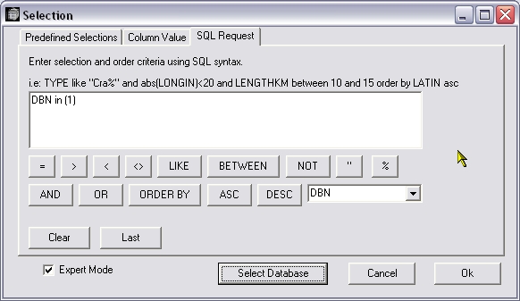
- "=" is for"equal to".
- ">" is for "upper than"
- "<" is for "lower than"
- "<>" is for "is different of"
- "<=" is for "Choosen column value lower or equal to"
- ">=" is for "Choosen column value upper or equal to"
- "LIKE" is for "contains".
- "BETWEEN" is for "between".
- "NOT" is for "not".
- The "quotes" are use to delimit an alphanumerical chain.
- % is a "joker" that is used to replace a part of an alphanumerical chain
- "AND" is for "and".
- "OR" is for "or".
- "ORDER BY" is for "ordered by".
- "ASC" is for "ASCII", that's to say an alphanumerical chain.
- "DESC" signifie "".
Beware : there must have an exact correspondance between your request text and the SQL language syntax, or mistakes notes will appear.
For example, the following request :
TYPE LIKE "Cra%" AND LENGTHKM BETWEEN 30 AND 35 ORDER BY LATIN
will select IN ALL THE DATABASES PREVIOUSLY CHOOSEN, the formations for which the field TYPE contains the letters "Cra" (as the cra-ters and the cra-terlets), withe the field LENGTHKM (lenght in km) value is comprised between 30 and 35 (km) and will sort them according to growing LONGIN field value (growing longitude).
The following request :
COUNTRY = "France" AND WORK LIKE "%ician"
will select IN ALL THE DATABASES PREVIOUSLY CHOOSEN, the formations for which the field COUNTRY (Orignin country of the character of the name) is equal to France and whose work field will contain "ician" (And mathematiciens, geophysicians, musicians...)
These two examples show well the power of the SQL request. To use completely this power, we have to remain the fields databases contents :
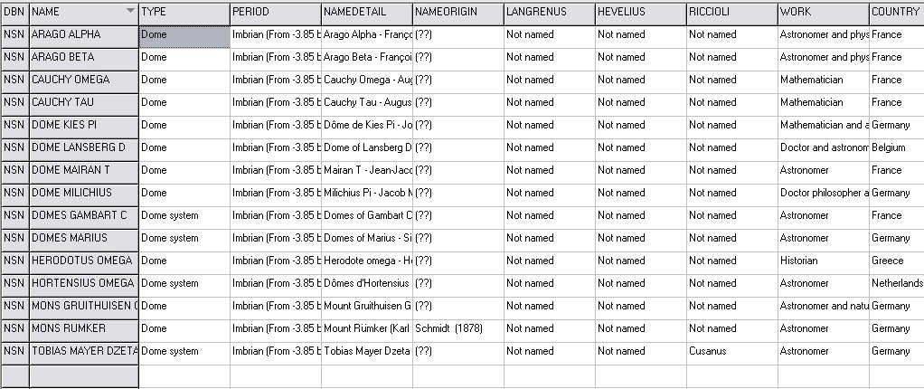
Quick description of fields names (The link conducts to a detailed description) :
DBN = Name of the database containing the formation
NAME = Official name of the formation
TYPE = Type of theformation
PERIOD = Creation period of the formation
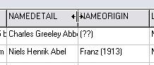
NAMEDETAIL = Detailed name of the formation
NAMEORIGIN = Name of the creator of the name
of the formation
LANGRENUS = Name given by Langrenus to the formation
HEVELIUS = Nom given by Hevelius to the formation
RICCIOLI = Nom given by Riccioli to the formation
WORK = Work of the character whose name has been given
to the formation
COUNTRY = Nation of the character whose name has
been given to the formation
NATIONALTY = Nationalty of the character whose
name has been given to the formation
CENTURYN = Century (Number) of living of the character
whose name has been given to the formation
CENTURYC = Century (Letters) of living of the character
whose name has been given to the formation
BIRTHPLACE = Birth place of the character whose
name has been given to the formation
BIRTHDATE = Birth year of the character whose
name has been given to the formation
DEATHPLACE = Death place of the character whose
name has been given to the formation
DEATHDATE = Death year of the character whose
name has been given to the formation
FACTS = Important facts during the life of the character
whose name has been given to the formation
LONGIN = numerical value of the longitude of the
formation
LONGIC = Alphanumerical value of the longitude of
the formation
LATIN = numerical value of the latitude of the formation
LATIC = Alphanumerical value of the latitude of the
formation
QUADRANT = Lunar quadrant where is situated the
formation
AREA = Large Moon area where is situated the formation
RUKL = Number of the map of Rükl's atlas where
is situated the formation
RUKLC = Title of the map of Rükl's atlas where
is situated the formation
VISCARDY = Number of the map of Viscardy's atlas
where is situated the formation
HATFIELD = Number of the map of Hatfield's atlas
where is situated the formation
WESTFALL = Number of the map of Westfall's atlas
where is situated the formation
WOOD = Indication of Charles Wood articles about the
formation
LOPAM = Number of the map of the atlas of Lunar Orbiter
where is situated the formation
LENGTHKM = Formation length in km
LENGTHMI = Formation length in miles
WIDEKM = Formation width in km
WIDEMI = Formation width in miles
HEIGHTM = Formation height in m
HEIGHTFE = Formation height in feet
RAPPORT = numerical ratio Length / Height of the
formation
PROFIL = Visualization of theprofile of the formation
GENERAL = General description of the formation
SLOPES = = Description of the surroundings of the
formation
WALLS = Description of the interior of the formation
FLOOR = Description of the bottom of the formation
INTERESTN = numerical value of the interest of
the observation of the formation
INTERESTC = Description of the interest of the
observation of the formation
LUNATION = Lunation day making easier observation
of the formation
MOONDAYS = Lunation day making easier observation
of the formation on the evening
MOONDAYM = Lunation day making easier observation
of the formation on the morning
DIAMINST = Diameter in mm of the theoritical instrument
necessary to observe the formation
THINSTRU = Name of the theoritical instrument necessary
to observe the formation
PRINSTRU = Name of the practical instrument necessary
to observe the formation
When a selection criteria is based on a numerical field (ex : RUKL, LENGTHKM, INTRESTN, etc...), the value to find must be in the request without quotes (ex : RUKL = 45). When a selection criteria is based on an alphanumerical field (ex : COUNTRY, FACTS, GENERAL, INTERESTN, etc...), the value to find must be in the request with quotes and jokers (ex : GENERAL LIKE = "%flat floort%").
Upper or lower case letters must be also respected (Ex : "%Flat%" is different of "%flat%").
For a detailed description of the databases fields contents, please go to the special chapter at the end of this manual.
This menu opens a special window for selecting the columns to be displayed for the selection list. It's possible that some kinds of informations don't interest you and that you don't wish to scan all the "width" of the list to see those that you are looking for.
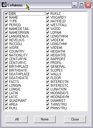
Fill the boxes of the columns that you want to display. The more you select, the more important for the display delay. If your computer is not too powerful, select the useful minimum.
The "All" button select all the columns in a single operation and the button "None" is for the reversed operation.
Close the window once the selection operation is done with the button "Close"
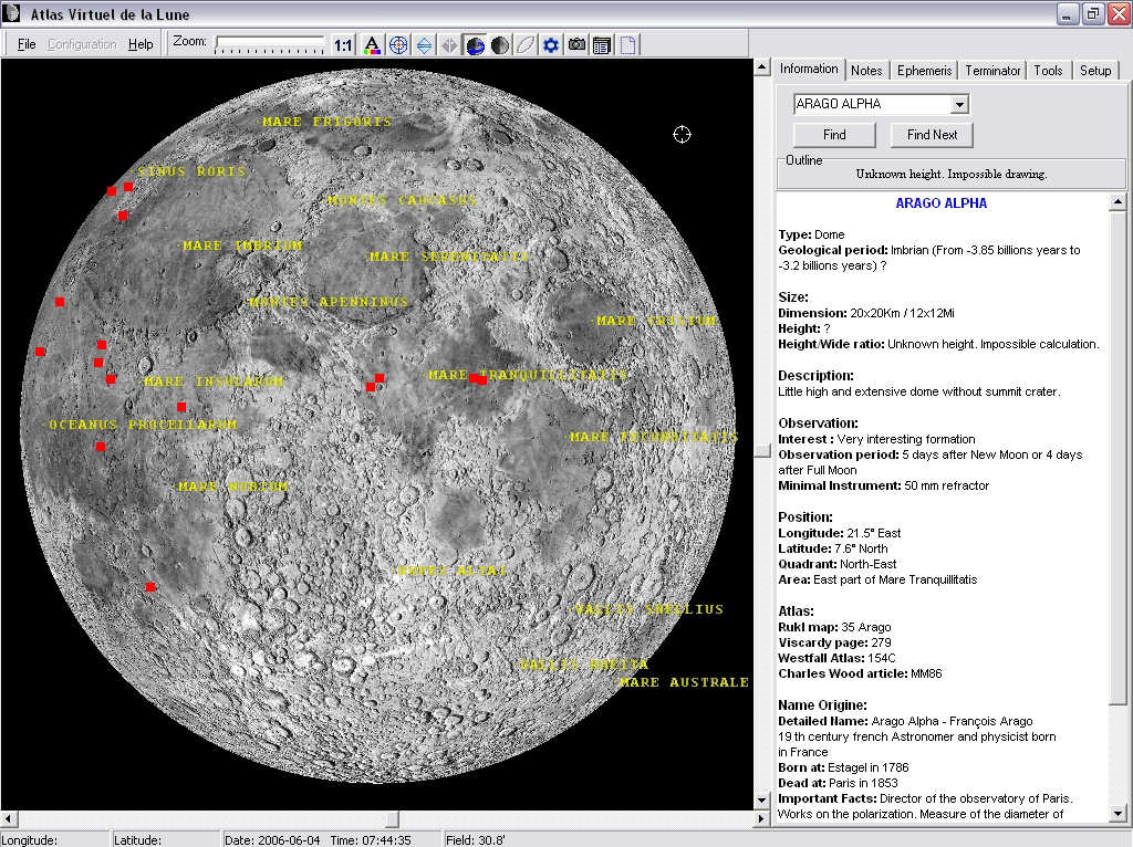
This menu is not eally a menu, but a direct command that will show you the power of the association between DATLUN and VMA. When you click on it, you will open the Virtual Moon Atlas and see all the formations that you have selected in DATLUN on the displayed map marked with big squares.
For example, if you have selected the Nearside domes (rather not numerous presently in the databases), here is what you obtain:
Other example :
You can also, for example select for study (because you can't observe them, all the craters chains (CATENA) of the Farside (Database FSN) and mark them on the map :
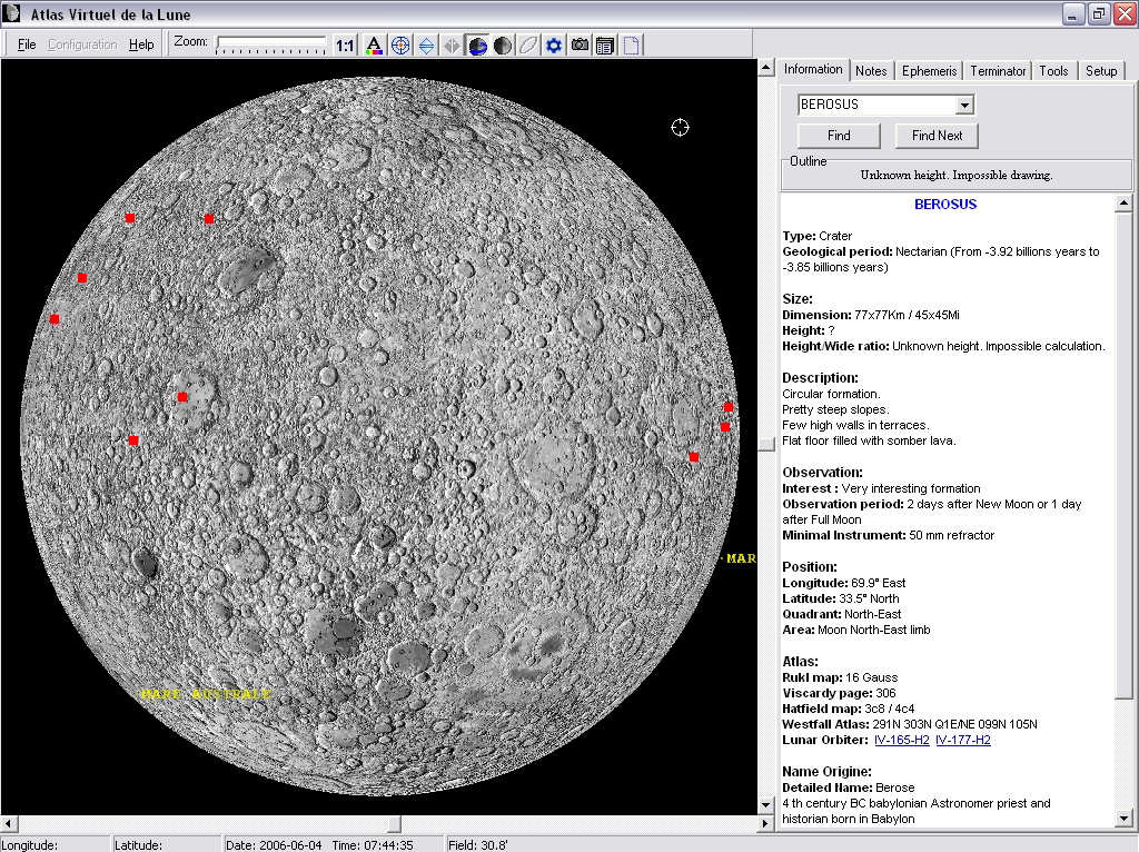
After that, when clicking on one of the squares, this formation will be selected in VMA and you will be able to access all its informations and pictures.
Last example, here are all the craters with a flat and somber floor (FLOOR LIKE "%flat%" and FLOOR LIKE "%somber%") of the Nearside. There are 38.
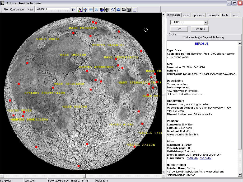
Sure, you find among them the famous Billy, Zupus, Grimaldi and Plato.
This three exemples have certainly showed you the possible studies because of the unique informations contained in the databases of VMA compiled by Christian Legrand.

As a classic in all the Windows (c) software, it's used in DATLUN to launch the present documentation with" Help" and display the credits with "About".
The list window owns some functions that improve the previous ones.
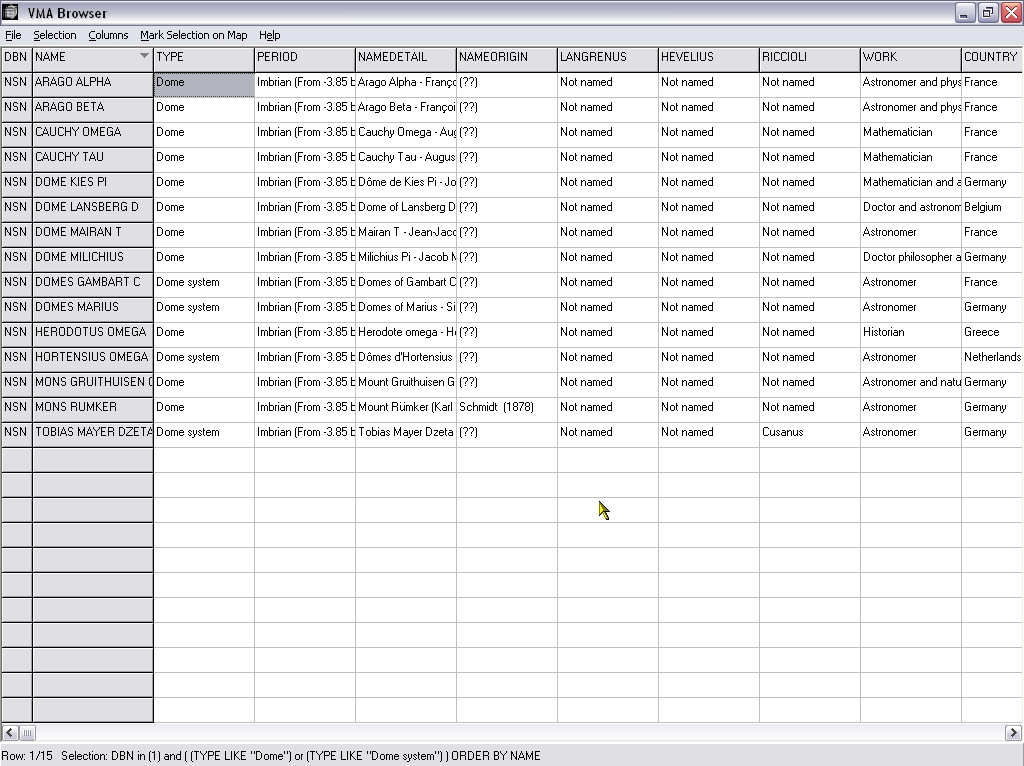
First, you can note thes two left columns in grey. They are mandatory and cannot be deleted. Horizontal and vertical lifters allows you to "travel" in the list..
If you click on the greyed title of one columns in the upper line, this liste will be sorted in the numerical growing order (if the field is numerical) or alphanumerical (if the field is alphanumeric). If you click a second time on the same title, the list will be sorted in the decreasing order.
You can also adjust the columns width when you put the cursor on grey titles bar, to the border between two columns. A new cursor then appears.
Cick on the left mouse button, stay clicked and go on left or right to increase or decrease the column width.
If you can't display all the length of a field because it's too long (FACTS, GENERAL...), put the cursor on it. A bubble will appear with all the field text in it.
In the list, you can select in grey, by clicking one time on it, one line so that you will not loose it when you go on the right of the list.
If after that, you double_click on the selected line, VMA will shows
you directly the selected formation.
THE STATE BAR
![]()
The state bar indicates you several things :
It can be the number of the line of the selected line compared to total number of lines of the selection list
Or it can be the text of the SQL request that generates the list.
DETAILED DESCRIPTION OF THE IMPORT OPERATION
This function allows you to import a personal formations list compiled in a CSV file and import it as a VMA database.
When selecting this function, a new window appears :
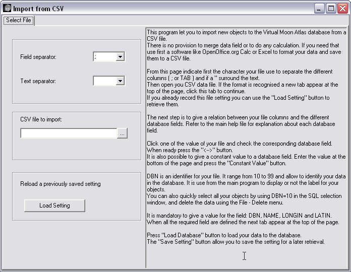
This program let you to import new objects to the Virtual Moon Atlas database from a CSV file.
There is no provision to merge data field or to do any calculation. If you need that use first a software like OpenOffice.org Calc or Excel to format your data and save them to a CSV file.
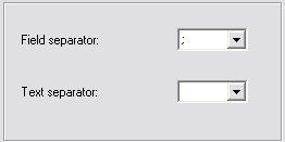
From this page indicate first the character your file use to separate the different columns ( ; or TAB ) and if a " surround the text.
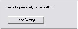
If you have precedently recorded prameters for one file, you can use the "Load setting" button :
If it's not the case, you must open the file with your personal datas. Indicate the directory of the file to import in the frame :
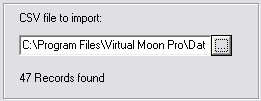
When the file is found, its records number is indicated. If the format is recognised a new thumbnail appear at the top of the page :
![]()
Click this tab to display the "Select data field" window".
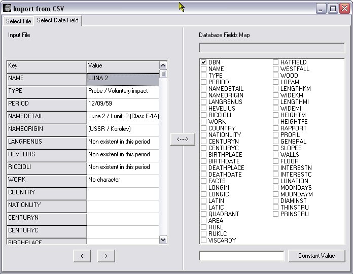
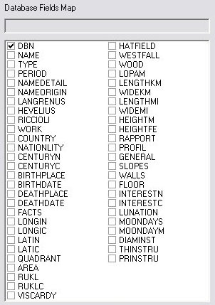
The next step is to give a relation between your file columns and the different database fields. Refer to "Databases fields" lower for explanations about each database field.
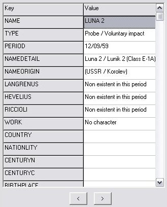
Click one of the value of your file to mark it in the left frame :
and check the corresponding database field in the right frame :
. When ready press the ![]() button.
button.
It is also possible to give a constant value to a database field. Enter the value at the bottom of the page :
![]()
and press the "Constant Value" button.
DBN is an identifier for your file. It range from 10 to 99 and allow to identify your data in the database. It is use from the main program to display or not the label for your objects. You can also quickly select all your objects by using DBN=10 in the SQL selection window, and delete the data using the File - Delete menu.
It is mandatory to give a value for the field: DBN, NAME, LONGIN and LATIN. When all the required field are defined the next tab appear at the top of the page.
![]()
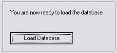
Click on it to display the backup frame :
Press "Load Database" button to load your data to the database.
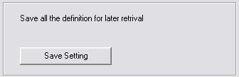
The "Save Setting" button allow you to save the setting for a later retrieval.
The software informs you of the operations during them.
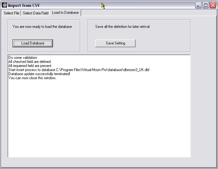
Import operation is then finished..
DETAILED DESCRIPTION OF THE DATABASES INFORMATIONS
The database of the "Pro" version of VMA is the most important detailed lunar database existing today. It's divided in several sections :
Nearside named formations : The formations of the Nearside which have a specific name (eg : Clavius, Rima Hyginus, Montes Alpes...). About 1100 entries.
Nearside indexed craters : The formations of the Nearside which don't have a specific name (eg : Clavius D, Hyginus A, Plato B...). About 5300 entries.
Farside named formations : The formations of the Farside which have a specific name (eg : Tsiolkovsky, Mare Moscoviense...). About 650 entries.
Farside indexed craters : The formations of the Farside which don't have a specific name (eg : Tsiolkosky D, Schrodinger A...). About 4100 entries.
Historical sites : The sites of all voluntary or accidental human impacts or landing sites (eg : Apollo 15 Base, Ranger 7, Luna 9, Apollo 17 S IV B... / 58 entries).
For each formation, available information is :
- the formation name origin.
- the main lunar atlases for amateur astronomers page where to find
the formation.
- the formation location on the lunar disc.
- the formation description.
- various useful information for serious observing.
These databases have been translated from French by a French man. Please forgive the rather poor English that has been used and language mistakes that you can find. You can report them to Christian Legrand. They will be corrected as soon as possible.
Warning : In such detailed work, the data will certainly contain some mistakes - mainly input mistakes. You can also report them to Christian Legrand so that he can correct the database. The authors thank you in advance for your cooperation.
The VMA database will be constantly improved and enhanced in the future versions to bring you more and more informations on more and more formations. Please, have a look periodically on our Web site to be informed about updates.
Informations of the VMA databases are copyrighted "(c) Christian Legrand" and can't be used outside of the software. For any other use, please contact the author.
Database detailed information presentation
DBN = DATABASE NAME :
It's a short name for each name of databases uses by DATLUN.
- NSN = "Nearside named", for named formations
of Nearside.
- FSN = "Farside named", for named formations
of Farside.
- NSI = "Nearside indexed", for named with letters
formations of the Nearside.
- FSI = "Farside indexed", for named with letters
formations of Farside.
About the personal databases that you would have imported, DBN is a number comprised between 10 to 99 permiting their identification. It's also used to choose the label display of your objects. It allows also to visualze your objects if entering DBN = 10 to 99 in the SQL request, and to delete your datas with the "File - Delete" menu.
NAME = OFFICIAL NAME :
This field presents the formation main name in Latin used officially
by the International Astronomical Union in capital letters. In the "Historical
sites" database, it's the name of the mission (eg : Apollo 15
Base, Ranger 7, Luna 9, Apollo 17 S IV B...)
TYPE = FORMATION TYPE :
This field contains formation type according with tradition or International Astronomical Union, plus some specific additions :
- Cape
- Cliff
- Crater
- Craterlet
- Crater chain
- Dome
- Gulf
- Lake
- Marsh
- Mountain
- Mountains range
- Plain
- Probe
- Rille
- Rilles system
- Sea
- Tray
- Valley
- Walled plain
- Wrinkle ridge
- Wrinkle ridges system
The "Historical site" database contains specific types :
- Human mission / soft landing
- Inert equipment / voluntary impact
- Inert equipment / unvoluntary impact
- Probe / voluntary impact
- Probe / unvoluntary impact
- Probe / soft landing
PERIOD = FORMATION PERIOD :
Formation age is indicated according to the lunar period of birth. The 6 generally admitted periods in present literature are :
Pre-Nectarian : (-4550 MY to -3920 MY)
Nectarian : (-3920 MY to -3850 MY)
Lower Imbrian : (-3850 MY to -3800 MY)
Upper Imbrian : (-3800 MY to -3200 MY)
Eratosthenian : (-3200 MY to -1100 MY)
Copernician : (-1100 MY to present days)
MY = Millions years
Indicated age has been extracted from remarkable book of Don E. Wilhelms and his team : "The geologic history of the Moon", USGS publication n 1348 of 1981. Maps and texts of this book have provided about half of the indicated ages. Written after Apollo missions, this book contains most of this period's discoveries.
In this "bible", some craters are ideal examples of each of the 6 above periods. They have been indicated in the database as "Typical".
The other half of the age data has been obtained from the geological map of the Moon, also realized by Don E. Wilhelms and his team in 1971. Formation age is less precise on this map. Indicated ages have a "?" at the end to show the lesser precision. More, this map has only 4 periods :
Pre-Imbrian : (-4550 MY to -3850 MY) that contains Pre-Nectarian
and Nectarian.
Imbrian : (-3850 MY to -3200 MY) that contains Lower and Upper
Imbrian.
Eratosthenian : (-3200 MY to -1100 MY)
Copernician : (-1100 MY to present days)
For some formations, it was not possible to find information about the birth period. Then, it's indicated "Birth period not found".
In the "Historical site" database, the launch date is indicated in this field.
NAME ORIGIN :
This field presents the real name of the person whose name has been given to the formation. When it also exists, a nickname is indicated between parentheses.
For other formations than craters, the official name is first translated
in English, and then you can find the real name of the person whose
name has been given to the formation.
This field indicates, when it's known or supposed, the organization or
person name that has given the name to the formation. Also included in
this chapter is the year of nomination when it has been found. In this
paragraph, IAU means" International Astronomical Union ". You can find
mainly 3 origins:
- Hevelius
- Riccioli
- IAU
But also others selenographers as Schröter, Schmidt...
When the origin has not been found, the field contains (??). Additionally, some uncertain origins end with "?".
These name origins are purely indicative and are not to be held as rigorously exact because of numerous additions made during all periods to the lunar nomenclature.
In the "Historical sites" base, it's the country and the agency which conceived the mission that are indicated.
This field indicates the name given by Michel Florent Van Langren on his Moon map in 1644. When the formation has not received a name, "Not named" is indicated.
This field indicates the name given by Johannes Hevelius on his Moon map in 1647. When the formation has not received a name, "Not named" is indicated.
RICCIOLI = Name given by Riccioli :
This field indicates the name given by Riccioli on the Moon map drawn in 1651 by Francesco Grimaldi. When the formation has not received a name, "Not named" is indicated.
WORK = Works :
This field indicates, for craters, the activities of the person whose name has been given to the formation.
Here is the list of the"works" you can find in the database:
- Agronomist
- Alchemist
- Admiral
- Anthropologist
- Archaeologist
- Archbishop
- Architect
- Artist
- Astronaut
- Astronomer
- Astrophysicist
- Aviator
- Banker
- Biologist
- Botanist
- Calif
- Cartographer
- Chemist
- Clockwork
- Consul
- Cosmographer
- Egyptologist
- Engineer
- Engraver
- Explorer
- Geodesist
- Geographer
- Geologist
- Geometer
- Geophysicist
- God
- Hero
- Historian
- Humanistic
- Hydrographer
- Inventor
- Jurist
- King
- Manufacturer
- Mathematician
- Meteorologist
- Mineralogist
- Missionary
- Mythological fame
- Naturalist
- Navigator
- Oceanographer
- Optician
- Paleontologist
- Pharmacist
- Philologist
- Philosopher
- Physicist
- Physiologist
- Poet
- Political man
- Priest
- Printer
- Professor
- Scientist
- Sailor
- Saint
- Sismologist
- Sponsor
- Stateman
- Technician
- Theologian
- Writer
- Zoologist
Please note that some people have been credited with 2 or 3 works.
This field contains the country where has lived the character whose name has been given to the formation. You can find disapeared countries. See also the list of nationalties here below.Ce champ indique le pays d'origine du personnage ayant servi à nommer la formation. On peut trouver des nations disparues aujourd'hui. Cf la liste des nationalités ci-dessous.
This field indicates the nationality generally attributed to the person whose name has been given to the formation. It can be the birth nationality. You can also find nationalities no longer in existence.
Here is the list of nationalities present in the database:
- American
- Arabian
- Australian
- Austrian
- Babylonian
- Belgian
- British
- Byzantine
- Brazilian
- Canadian
- Carthaginian
- Castillan
- Chinese
- Cretian
- Dalmatian
- Danish
- Dutch
- Egyptian
- English
- Finnish
- French
- Greek
- German
- Hungarian
- Indian
- Irish
- Italian
- Japanese
- Jewish
- Macedonian
- Mexican
- Norwegian
- Persian
- Polish
- Portuguese
- Roman
- Russian
- Scottish
- Soviet
- South African
- Spanish
- Swedish
- Swiss
- Czech
- Venetian
This field indicates the number of the century during which the character whose name has been given to the formation most spent most of his life. For example : 19 for "19 th century".
This field indicates clearly the century during which the character whose name has been given to the formation most spent most of his life. For example : "19 th century".
This field indicates the birth place of the person whose name has been
given to the formation when it has been possible to find it. If not found,
it is indicated " ? ". Please note that for imaginary persons, there
is no birth place.
This field indicates the birth year of the person whose name has been
given to the formation if it has been possible to find it. If not found,
it is indicated " ? ". Please note that for imaginary persons, there is no
birth year.
This field indicates the place of death for the person whose name has been given to the formation when it has been possible to find it. If not found, it is indicated " ? ". Please note that for imaginary persons, there is no place of death.
This field indicates the year of death for the person whose name has
been given to the formation if it has been possible to find it. If not
found, it is indicated " ? ". Please note that for imaginary persons, there
is no year of death.
This field describes prominent facts during the life of the person whose name has been given to the formation if it has been possible to find it. If not found, it has been indicated " ?? " .
This information is adapted from information given by the International Astronomical Union, and additional data coming from various bibliographical sources.
Generally, you can find the discoveries, inventions and important works attributed to the person, as well as distinctions obtained during life (nominations, price. ..) with associated dates when they have been found.
POSITION :
This field gives the numerical value of the selenographic longitude of the formation with a tenth of degree precision. This data is provided by International Astronomical Union. Longitude is negative to the West of central meridian. About craters, it's the center longitude. For lengthened or irregular formations, it's an internal point the closest to central.
You can find here the alphanumerical selenographic longitude of the formation
with a tenth of degree precision. This data is provided by International
Astronomical Union. Longitude is negative to the West of central meridian.
About craters, it's the center longitude. For lengthened or irregular
formations, it's an internal point the closest to central.
You can find here the numerical selenographic latitude of the formation with a tenth of degree precision. This data is provided by International Astronomical Union. Latitude is negative to the South of lunar Equator. About craters, it's the center longitude. For lengthened or irregular formations, it's an internal point the closest to central.
You can find here the alphanumerical selenographic latitude of the formation with a tenth of degree precision. This data is provided by International Astronomical Union. Latitude is negative to the South of lunar Equator. About craters, it's the center longitude. For lengthened or irregular formations, it's an internal point the closest to central.
Information has been included to make easier the location of the formation on the lunar disk. The location system is that of the International Astronomical Union since 1988. When you look at the lunar disk with the naked eye, the North is up and the East is right.
This first field indicates the lunar quadrant where is situated the formation according to the "Lunar Quadrant Charts" by Arthur and Agnieray published by the University of Arizona :
- North-East
- South-East
- North-West
- South-East
This field indicates clearly the lunar region where can be found the
formation according to a more known one (sea, mountain or large crater)
or according to the position on the edge of the lunar disk (limb) or according
to the center of the lunar disk.
ATLAS :
This field contains pages, maps or picture of the main paper atlases presently available on which the selected formation is indicated.
RUKL = Number of the page of "Atlas of the Moon" by Antonin Rkl :
In honor to its author for his contribution to Astronomy popularization,
we have mentioned the map number of the "Atlas of the Moon" by
Antonin Rkl on which is found the formation.
RUKLC = Title of the page of "Atlas of the Moon" by Antonin Rkl :
We have also mentioned the map number of the "Atlas of the Moon" by Antonin
Rkl on which is found the formation.
VISCARDY = Page of the "Atlas photographique lunaire à haute résolution" by Georges Viscardy :
Also in honor to its author for his contribution to Astronomy popularization,
we have also mentioned the page number of the "High resolution photographic
Atlas of the Moon" by Georges Viscardy on which the formation
is found with a text on it, or on which a photograph shows the place where
is situated the formation.
For this last work, when the formation does not figure on at least
one photograph, there is no page indicated. Similarly, if the formation
appears on, at least, a photograph, but is not described in the text,
it is the page of the best photograph where it is normally visible that
is indicated.
HATFIELD = Page of the "Photographic Atlas of the Moon" by Hatfield :
In honor to its author for his contribution to Astronomy popularization,
we have mentioned the map number of the "Hatfield Atlas of the Moon"
republished by Jeremy Cook on which the formation is found.
WESTFALL = Page of the "Atlas of the lunar terminator" by Westfall :
In honor to its author for his unique work, we have mentioned the maps numbers of the "Atlas of the Lunar Terminator" from Professor John E. Westfall on which the formation is found, because it's the only one that shows all librations variations.
We mentioned Charles Wood's articles on numerous formations
edited in Sky and Telescope and the number of his "Lunar
100 list", with his courtesy.
Adding to downloadable picture of the LOPAM, we have indicated numbers of "Lunar Orbiter Photographic Atlas of the Moon" pages on which you can find the selected formation. Just click on this link and go to the Internet site of Jeff Gillis of Lunar and Planetary Institute and you will admire the entire picture from which was extracted the picture.
Nevertheless, if you are not permanently connected to the Internet, another possibility is offered.
You can modify the "lopamidx.txt" file which is in the "Database" sub-directory of the "Virtualmoon" install directory with a text editor as "Windows notepad". After, you can access directly to the LOPAM pages copied on your hard drive or on a recorded CD.
In this file, you have just to indicate after "Local URL=" the path of your support where are stored your LOPAM pages, and the pictures type after "SUFFIX=". For example :
Local:URL=c:\Program files\Virtualmoon\LOPAM pages\SUFFIX=.jpg
can access to LOPAM pages stored in the sub-directory "LOPAM pages" of the install directory "Virtual moon" as ".jpg" files.
New example :
Local: URL=d:\ SUFFIX=.bmp
can access to LOPAM pages stored in the root of a CD placed in a CD reader called "d:" as ".bmp" files.
The four following fields contain data about formation dimensions.
These vary from different bibliographic sources. First indicated is data
provided by International Astronomical Union, then those coming from other
sources when they seem more accurate. Some of them have been also
directly measured on atlases or photographs when they were not found in
literature.
In the "Historical sites" database, these fields are
empty.
This first field indicates the formation length in km. For craters,
length is very often equal to width because it's the mean diameter.
This first field indicates the formation width in km. For craters,
length is very often equal to width because it's the mean diameter.
This first field indicates the formation length in miles. For craters,
length is very often equal to width because it's the mean diameter.
This first field indicates the formation width in miles. For craters,
length is very often equal to width because it's the mean diameter.
You find here relative altitudes, not absolute ones referring to the
mean lunar sphere. It gives the formation height in meters when it's known.
For craters, it's the difference between the upper part of the internal slopes and the floor.
For other formations, it's the difference between the formation summit and surrounding land.
For mountains and mountain ranges, it's a mean height and higher summits height is generally detailed in description fields.
For rilles and scarps, it's the difference between surrounding lands
and the formation lower floor.
You find here relative altitudes, not absolute ones referring to the
mean lunar sphere. It gives the formation height in feet when it's known.
For craters, it's the difference between the upper part of the internal slopes and the floor.
For other formations, it's the difference between the formation summit and surrounding land.
For mountains and mountain ranges, it's a mean height and higher summits height is generally detailed in description fields.
For rilles and scarps, it's the difference between surrounding lands
and the formation lower floor.
This data is only indicated for formations whose height is known. It's very often given for craters where it means the diameter / height ratio.
In this frame, outline of the formation selected within your search and whose description is in the "Database window" is displayed. Here is a semi-graphic field presenting the formation profile. This information is only provided when height is known.
Profile has not be constructed for some formations types :
- Sea
- Lake
- Gulf
- Marsh
- Ocean
- Probe
- Human mission
The profile is generated according to the following description :
Crater outline :
Crater is presented so :
A________________A
< n characters>
"A" characters show the slope height. The number of "_" characters shows the crater width with the same scale as height.
Because the "A" character is twice high than wide on an html screen,
in the above example, the width / height crater ratio is 1/8.
The central mountain of crater has not been represented because their height has often not been found.
Don't forget that each formation has its own profile. You can't compare two craters dimensions using their profile representation.
A__________A Profile of (Length =20 km & height = 4000 m)
A__________A Profile of (Length = 5 km & height = 1000 m)
On screen, these two profiles are identical, but as you
can see, dimensions are different.
Relief outline :
For mountains, mountains ranges, wrinkle ridges or domes, an other viewing mode is selected :
___A___
"A" character shows the formation maximum height. The number of "_" characters shows the formation width with the same scale as height.
Rille outline :
For rilles, rilles system and valleys, profile is shown like this :
___ ___
V
"V" character shows the formation maximum depth. The number of "_" characters shows the formation width with the same scale as depth
DESCRIPTION :
This field is divided in four sections for the formation detailed description.
But this division is not really visible when consulting the
formation form on screen or printing it.
Cardinal points are reference to indicate where the different details are situated according to formation center. For a crater, reference point is the area center.
If observed with naked eye, on the Moon, North is up, South is down,
West is left and East is right.
North
North-West___________________North-East
Formation
center
South-West_____________________South-East
South
For example, a craterlet located on a crater wall down left will be described
as "Walls ridden by a craterlet at South-West".
Craters are the most numerous formations. Their description is well divided in four parts.
First, information about shape, location and preservation of the formation.
In the "Historical sites" database, specific description are present :
- Lauch date and hour
- Names of astronauts if it's a human mission
- Spaceship or probe description
- Main dates and hours of the mission
- Main scientific results
Then, the external "slopes" are described. Generally, the comments are about their inclination. If radial valleys are present, slopes are described as "tormented". This part also indicates craters and craterlets situated on external slopes.
The "walls" which are described are the internal ones. They link the upper rim of the slopes to the crater floor. The walls are described as "little high when the altitude difference is less than 2,000 m, "pretty high" between 2,000 and 3,000 m, "high" between 3,000 and 4,000 m and "very high" if more than 4,000 m. The indicated information is that which seem the most believable according to important variations in different bibliographical sources. This part also indicates craters and craterlets situated on internal slopes.
The crater "floor" is described as "flat" if no hills can be found to
"tormented" if it's very irregular. The non circular shape is
mentioned. If lava seems to have flooded the crater floor, it has been
indicated. This part also indicates craters and craterlets situated on
the floor.
This field gives a numerical indication on the interest of the formation.
It will help you to determine which formations to observe. It gives you
information on the formation interest. It has been defined by the authors
according to their own experience. Sure, you can disagree with them.
Formations are indicated as :
- Low interest formation (1)
- Pretty interesting formation (2)
- Very interesting formation (3)
- Exceptionally interesting formation (4)
This field gives a numerical indication on the interest of the formation.
It will help you to determine which formations to observe. It gives you
information on the formation interest. It has been defined by the authors
according to their own experience. Sure, you can disagree with them.
Formations are indicated as :
- Low interest formation
- Pretty interesting formation
- Very interesting formation
- Exceptionally interesting formation
This gives an indication on the day of the first half (From New Moon to Full Moon) during which, a favorable observation of the selected formation on the terminator is possible. It's built on the formation longitude.
"3" is for "3 days after New Moon"
"7" is for "7 days after New Moon", it's First Quater
"14" is for "14" days after New Moon", it's Full
Moon
This expression means "Day of lunar month permitting an evening observation of the formation". It has been observed that Eastern limb formations can only be well observed 2 days after New Moon.
The indicated day is the one for a null libration. It has been computed
from formation longitude. According of the real libration value, it can
be shifted by one day more or less.
This expression means "Day of lunar month permitting an morning observation of the formation". It has been observed that Western limb formations can only be well observed 2 days before New Moon.
The indicated day is the one for a null libration. It has been computed
from formation longitude. According of the real libration value, it can
be shifted by one day more or less.
This field gives a numerical value of the diameter of the theoritical instrument needed to observe the whole selected formation.It's built on the formation diameter and the theoritical resolution of the instruments based on the Dawes formula.
This field presents the smallest instrument needed to theoritically observe the formation. It has been computed from the formation width and from theoritical resolution power (TRP) of the instruments. It is supposed to be obtained when using a magnification equal to instrument diameter in centimeters.
This data is provided for a Moon mean distance of 202,000 miles. An arc second is then about 1 mile on the Moon.
- Naked eye (PRP = 50 miles)
- x10 binoculars (PRP = 10 miles)
- 2" refractor (PRP = 2.5 miles)
- 4" reflector (PRP = 1.5 miles)
- 6" reflector (PRP = 1.1 miles)
- 8" reflector (PRP = 0.9 mile)
- 10" reflector (PRP = 0.6 mile)
This field presents the smallest instrument needed to comfortably observe the formation. It has been computed from the formation width and from practical resolution power (PRP) of the instruments defined as the double of TRP. It is supposed to be obtained when using a magnification equal to instrument diameter in centimeters.
This data is provided for a Moon mean distance of 202,000 miles. An arc second is then about 1 mile on the Moon.
This data depends on other external criteria such as instrument quality, observer's eye health, seeing...).
- Naked eye (PRP = 100 miles)
- x10 binoculars (PRP = 20 miles)
- 2" refractor (PRP = 5 miles)
- 4" reflector (PRP = 2.5 miles)
- 6" reflector (PRP = 1.6 miles)
- 8" reflector (PRP = 1.2 miles)
- 10" reflector (PRP = 1 mile)
END OF "DATLUN" USER'S MANUAL
The authors thank users to indicate them all mistake they found in this manual with a message on the Web site forum..