|
|
|

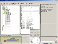
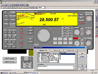
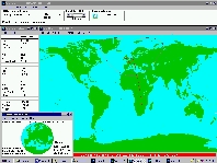
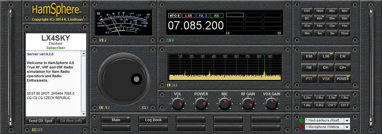
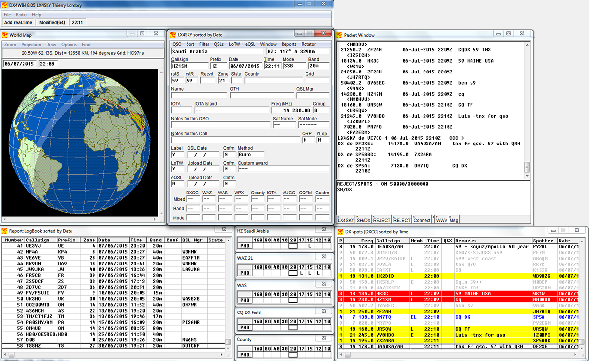
HamSphere
4 default interface
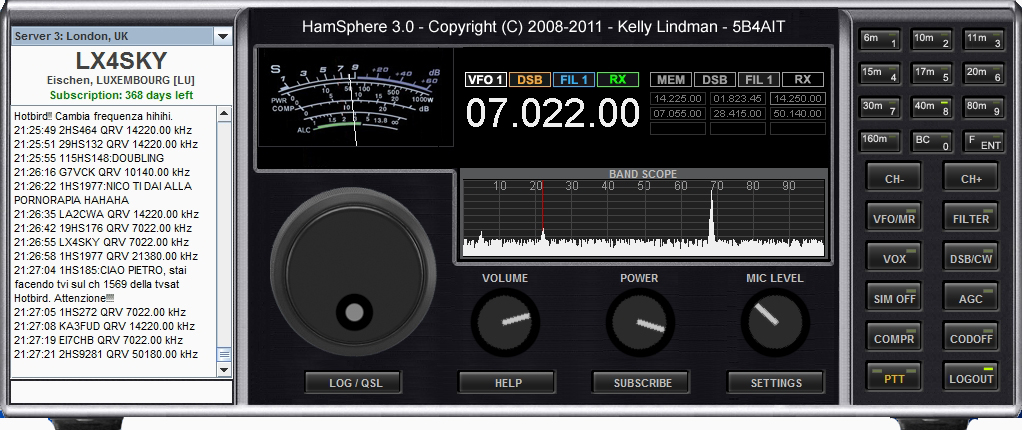
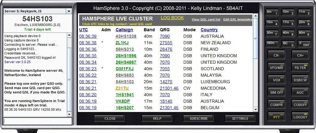
HamSphere
3 interface
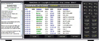
Live
cluster

eQSL's

(c)
2008-2014, HamSphere
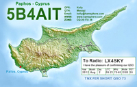
Kelly
Lindman, 5B4AIT, €30
|
HAMSPHERE
Pour les
francophones, consultez la revue
de HamSphere sur mon blog.
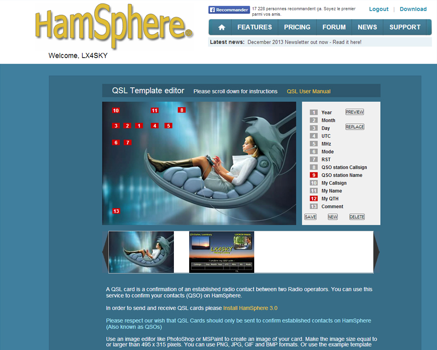
HamSphere has been developed
in 2008 by Kelly Lindman, 5B4AIT.
The Trademark is owned and operated by the private company RingJoeBing Holdings Ltd in Paphos, Cyprus.
HamSphere is a virtual shortwave
transceiver, i.e. an Internet communication system simulating shortwave propagations
over a virtual ionosphere.
Behind HamSphere there is a
mathematical algorithm for wave propagations based on a model and pre
recorded signal envelope. Multipath propagation is achieved by
inducing multiple simulated electromagnetic paths digitally thus
producing signal fading and audio distortion.
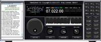
The
interface is skeuomorph, i.e. it is designed to look like to an
another object, in particular to the front panel of a HF
transceiver. The system
uses Software Defined Radio (SDR) technology : digital local oscillators,
filters, balanced mixers, carrier wave suppressors, modulators etc.
HamSphere takes advantage of several servers located in Europe (UK,
Sweden, Iceland) and USA to generate the virtual world of HamSphere.
HamSphere covers 6m to 160m ham band including 11m. It uses double side band modulation
(DBS) and each band is 100 kHz wide. It works also in CW.
Thanks to all this technology, when
you switch on HamSphere you have the same feeling as using a real
transceiver : you hear noises, scratches and other white noise (QRN)
as well as man-made interferences (QRM) and possible fading on bands.
Also, the
Double Sideband Modulation with carrier suppression generates the
famous "donald duck" sound when you swirl the knob.
On 10
and 6 meter bands, the simulation mode maintaining connections under natural
realistic conditions can be switched off. In this case you work in a
reliable VoIP and noise-free mode.
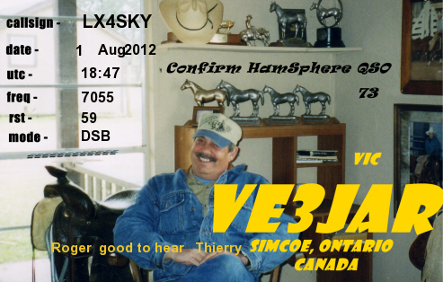
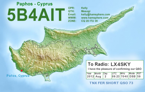
Currently
HamSphere is used by more than 8100 amateurs (and counting) in
245 DXCC entities. Tens new users are added each day. From one year to another, its popularity
is growing fast. In 6 years, more than 800,000 QSL cards have been
exchanged.
Why
using HamSphere when amateurs can work on the air ? Because some
amateurs cannot erect an antenna on their roof, they have no place to
install an antenna, they do not want to work on portable or mobile on
evenings, at night or during the winter and prefer to work at home.
Ham
radios, non-licensed amateurs and SWL will find in HamSphere an opportunity
to contact other fans of ham radio without the contraint of having
to succeed to an examination. In addition the interface is
realistic, nice, easy to use, and the activity really pleasant,
including contests too.
HamSphere
version 4.0 was released in 2014. It
comes with a new graphic user interface that you can customize from a
repository of modules to purchase
(skins, monoband and multiband beams, wire antennas, S-meter,
oscilloscop, speaker, cover plate, clock, etc). Unfortunately each
module will cost you between 15-25€ and can quickly become
expensive if you want to purchase e.g. 5 monobands antennas...
HamSphere
4.0 is based on a brand new implementation of the
Maidenhead locator grid and the propagation simulation is based
on the geographic coordinate of the user.
The propagation
between two grid squares is calculated from daily solar flux
data and its effect on the ionosphere. The sunspot number (SSN) is taken into account. The system also recognizes "Back-scatter",
"Sporadic-E", "Tropo" and "Grey Line" propagation.
In the new model, propagation conditions between two virtual
operators is determined by the sun's radiation and by the time of
the day, very much like the real HF propagation. These new algorithms
allow HamSphere to simulation minute-to-minute changes in the propagation.
HamSphere
4.0 also includes a better audio quality than version 3, a better
S/N ratio, a narrower communication bandwidth, real USB and LSB
modulations, both transmitter and receiver AGC, and plug-in modules
to suit your communication needs.
HamSphere
works on all Windows 32 and 64-bit platforms, Linux and Mac OS or
any other Java driven system, including on iPhone and Android
smartphones.
At
home you need a computer connected to Internet (cabling or Wi-Fi),
a speaker or a headset and a microphone (a webcam, wired or USB, can play that role).
The
trial version of HamSphere v3 or v4 is valid 5 days, what is much too short.
A full week, so including a weekend, or even 30 days should have been more
interesting. If you want the full version, you need to subscribe to
HamSphere. The
QSL database and the log book are not compatible between version 3
and 4 because of the new propagation algorithm used in v4. So if you
upgrade to HamsSphere 4 you will lost all your data : ther logbook,
QSL's sent and received and your awards,
what is really a pity. In
life, if I change of transceiver or antenna or move to another spot
showing a better propagation, my logbook and QSLs will not suddently
become invalid...
The membership is 30€ per year. When your first subscription will
be confirmed, non-licensed amateurs will receive a specifc call sign
(e.g. 12HS3456) which prefix depends on your country (code ISO2).
Licensed ham radios can use their own call sign.
All
members have access to a log book developed by VE3JAR, you can
manage eQSLs that you can create, receive and send via the tool, and to the
forum. You can also create a blog on HamSphere.Net.
If
you need more information or some help from HamSphere
administrators, the contact emails are this
one or this one.
Here is
an audio recording from
HamSphere 3.0 (MP3 of 612 KB). You
will find on YouTube videos showing HamSphere
in operation compared to a real
QSO using a transceiver. The HamSphere simulation is amazing by
its realism.

|
|
2002-2015,
Echolink
Freeware |
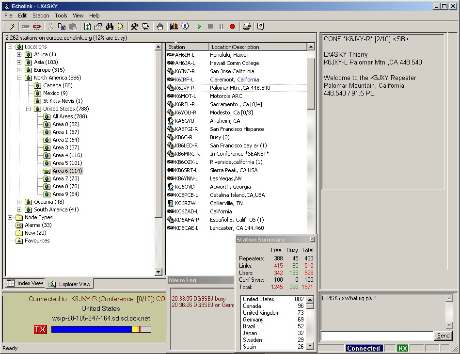
Echolink
Developed
in early 2002 by Jonathan Taylor, K1RFD, Echolink is a program that, instead of using
ionospheric layers to establish a communications, uses the Voice
over IP (VoIP) protocol, I.e. Internet.
You
can use Echolink in combination with RF linking and specially with V/UHF FM
transceivers to work amateur stations located all over the world, at
distances exceeding by far the performance of FM transceivers.
The product
has spread rapidly among the ham community and is today used by over
200,000 radio amateurs in 151 countries. At any point of the day, in
2015 there are about 5200
amateurs connected.
EchoLink
uses two different systems : repeater linking where repeaters
are linked each another through VoIP. Each OM works with a fixed,
portable or mobile VHF or UHF FM transceiver, and simplex linking
where the amateur use either a V/UHF handheld or mobile transceiver
directly connected to the Internet or directly his or her PC
connected to the Internet via a low speed modem (as low as 36K) or a
DSL connexion. The simplex linking can be established to other
simplex nodes, to repeaters or even to amateurs directly connected
to the Internet and using no ham equipment at all.
EchoLink
is only accessible to licensed amateurs (even if you are limited to
V/UHF or novice) and each amateur receive a personal node or
identifier. Among its useful features, conversations can be recorded
in .WAV files.
Echolink
runs on all Windows 32-bit platforms with or without firewall, and
required a standard multimedia platform (sound card, microphone,
and external speaker). Read my review.
|
|

Version
8.05

Version
5.03

(c)
1999-2013
DX4WIN,
$90 |
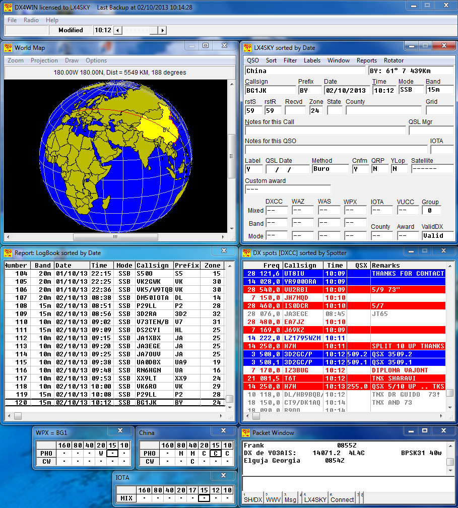
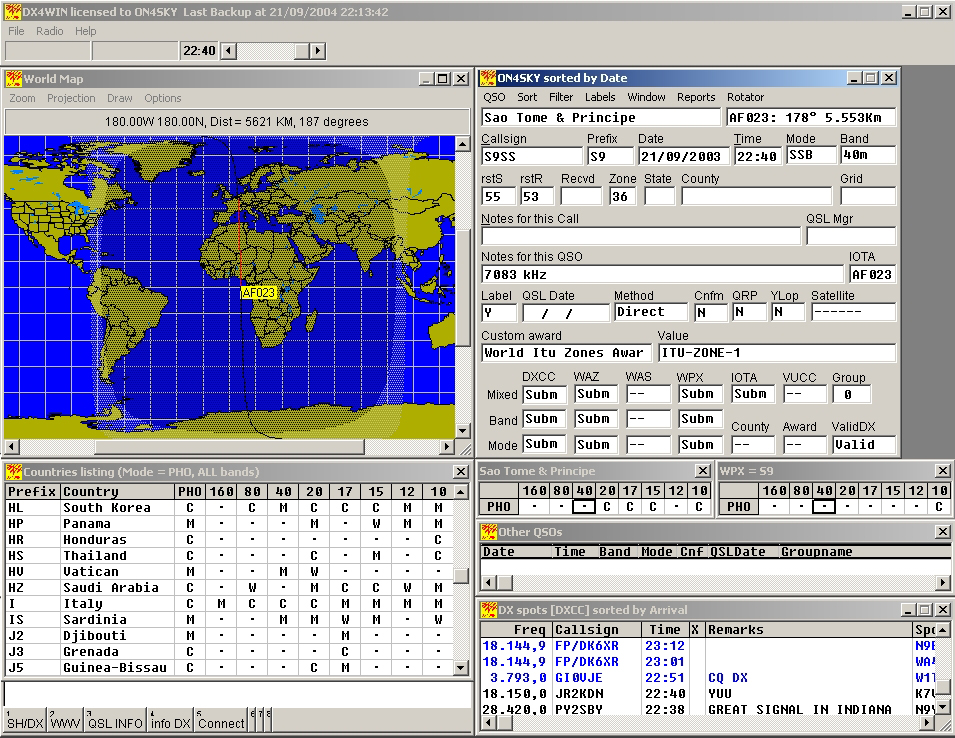
DX4WIN The
amateur radio regulation asks to licensed hams to keep a logbook of
their QSOs during one year counted from the last QSO recorded. DX4WIN
provides this solution and much more.
DX4WIN
has been developed by Paul J. Van Der Eijk, KK4HD, in 1999. It is
an electronic logging program dedicated to radio amateurs
(and to listeners in a lesser extent).
The
first action to do is to register your DX4WIN license in the main
menu. Then to place the various floating windows on the screen, and
at last to set your preferences in the main menu. These settings are
saved and even backuped.
The QSO window provides all information
about the station worked, including flags for awards, QSL
confirmation, free fields, and tables.
In
addition, several windows can be opened : a world map can be displayed in cartesian, equi-distant or spherical
projection, your logbook, the list of US states worked, US county or
WPX as well as dedicated reports (award related, IOTA or DX
entities confirmed, and more).
DX4WIN
includes the very demanding packed radio interface that provides
online assistance to amateurs on the air.
Indeed,
if your computer in linked to
Internet (in TCP/IP), it can connect to a cluster, encapsulating the TCP and IP frames in the AX.25
protocol. For this, a list of custers is included on the DX4WIN.TCP
file.
Once
connected and have entered a valid call sign, the system will display
live DX spots information, assigning colors to call signs depending
on default settings or the priority you set. You can also send
messages via the packet input/output window.
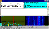
The world map
color can be customized (except that there is a bug in v8 and not
all colors are available). The map displays the gray line,
the name, distance and bearing to any DXCC entity pointed by the mouse
(the new version also displays DXCC and IOTA codes). As soon as you enter a new
call sign in the QSO window,
the world map highlights the currently working country in yellow
(but there is also a bug in v8) and displays the
path to this entity, including to islands (IOTA) if you completed
the concerned field, the short path being traced in red and the
great circle in black.
DX4WIN
can run in standard (full display) or contest (reduced set of fields)
mode and fill automatically some fields in querying automatically
several databases (DX entities, IOTA, QSL Managers, etc) that you
can edit.
DX4WIN
can also read external data (e.g. a callbook on CD-ROM),
display a band scope with signal strength, and provides interfaces
to driver the VFO or your radio, to rotate your antenna, to work on
PSK31 and many other digimodes, as well as a CW keyboard.
Via
the QSO window, DX4WIN can perform a search on any field,
sort your log, save reports (Worked WPX, worked DXCC, etc) in text files or print them (e.g. to
request an award) and print QSL labels. The
main menu allow you to save and backup (also set automatically) your
log, to import or export your log in TXT, ADIF or various DX4WIN
formats, and even merge several logbooks, to edit your report window
(what column to display), and set events in the calendar.
At
last, DX4WIN version 5 and higher support multiple logs, a way
to isolate a set of QSOs if you want for example create a subset for
all QSO worked under another call sign, from another location or
during a DX-pedition.
From
version 6, an updater is available (see the History
section to download it) to update automatically DX4WIN.AWD (award database), DX4WIN.CAL
(DX calendar), DX4WIN.CTY (country file, including ADIF.PMP and IOTA
islands), DX4WIN.MAS1 (DX4WIN.MAS, master callsigns), DX4WIN.MAS2 (eQSL/LoTW users list),
and DX4WIN.TCP (DX cluster node internet addresses)
Versions
8.02 and higher support eQSL and LoTW.
DX4WIN
is now at version 8.05 and runs on all Windows 32-bit and 64-bit platforms. A demo is
available.
|
|

(c)
2001-2004
Afreet
Software, Inc,
$29.95 |
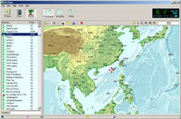
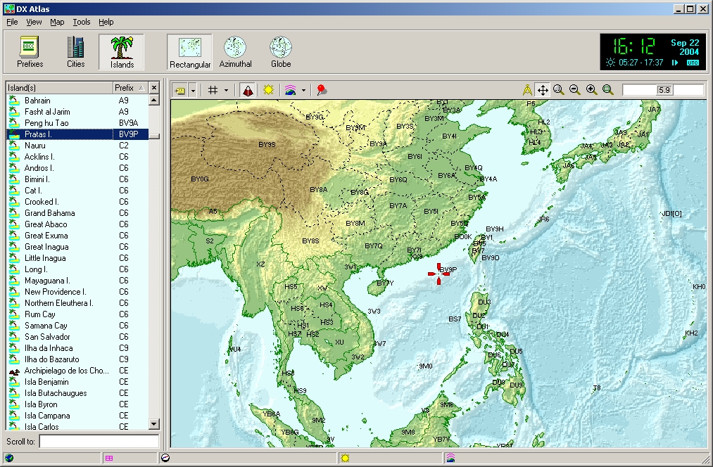
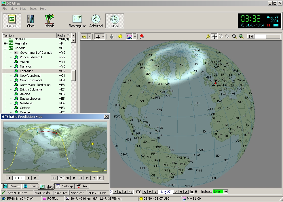
DX
Atlas
DX
Atlas is still often known for what it was in its first version released
in 2001, a superb geographical
atlas. The screen can be divided in two panes, the right one showing
the world map, the left pane a custom list (world prefixes, cities
or islands).
The
world map can be enlarged up to see individual islands in detail.
The world map can be covered with several overlays at a depress of a
button : the prefix of all DX entities, states, or islands, CQ
zones, ITU zones, grid locator, long/lat coordinates, the sun
position and gray line, and an optional topographic relief for both
lands and oceans. The contrast of the relief is adjustable. You can
also use the tool called the Great Circle Path (pressing an icon
showing a pair of compasses) to estime the distance (long and short
pathes) to any location pointed with the mouse, its heading, grid
square, coordinates (long/lat.) and time of sunrise/sunset.
All
overlays can be displayed in rectangular, equi-distant or spherical
projection. However, prefixes associated to the highest resolution
(e.g. showing russian oblasts, japanese districts, etc) can only be
displayed in rectangular projection.
In
addition, right-clicking anywhere on the map colored pins associated
to a comment (optional) can be added, and their position is
automatically saved when closing the program.
But
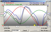
today, DX Atlas is much more than this. From
version 2.24 released in 2004, Alex
Shovkoplyas, VE3NEA, interfaced this fine atlas with the HF
propagation program Ham CAP to use the power of the VOACAP
engine and estime propagation conditions at a global scale. Allied
to a small tool named Ionoprobe it is able to predict the intensity
of the auroral oval, the MUF or the magnetic dip. Refer to my
detailled review
for more detail.
DXAtlas
runs on all Windows 32-bit platforms. It must be registered, the publisher
providing a 30-day-free-trial period.
|
|

1998,
2006, J.Mc Parlane
Freeware |
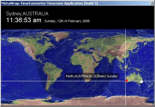
MetaWrap
Formely
known as Iridium
Clock,
it is an universal time converter displaying the time anywhere in the
world in 12 hour format (AM/PM). When a major city is selected, its
name and the local time are displayed in the upper pane. The time
displayed is based on your computer clock settings. Once loaded the
program can work in idle mode in the task bar. Developed by James Mc Parlane
for Iridium South Pacific Pty Limited
(IPS), it is no more supported as IPS surrended its Iridium
satellite carrier license in low orbit (LEO) in 2000. It intended to
create a network of terrestrial facilities in the South Pacific. The
help (pressing on the question mark or F1) linked to the global
iridium server is thus no more active.
The
new Build 3 released in 2006 optionally requests an active Internet
connexion. Indeed, in double-clicking on a location, the system
jumps to Google local to display a satellite picture of the area
(e.g. this extraordinary zoom in New
York). For this unique feature and despite its simplicity,
I have given it two new stars, four in total.
MetaWrap runs on all Windows 32-bit
platforms. Here is the previous version to download.
|
|

(c)
1996-2004
Nu-Ware,
$35 |
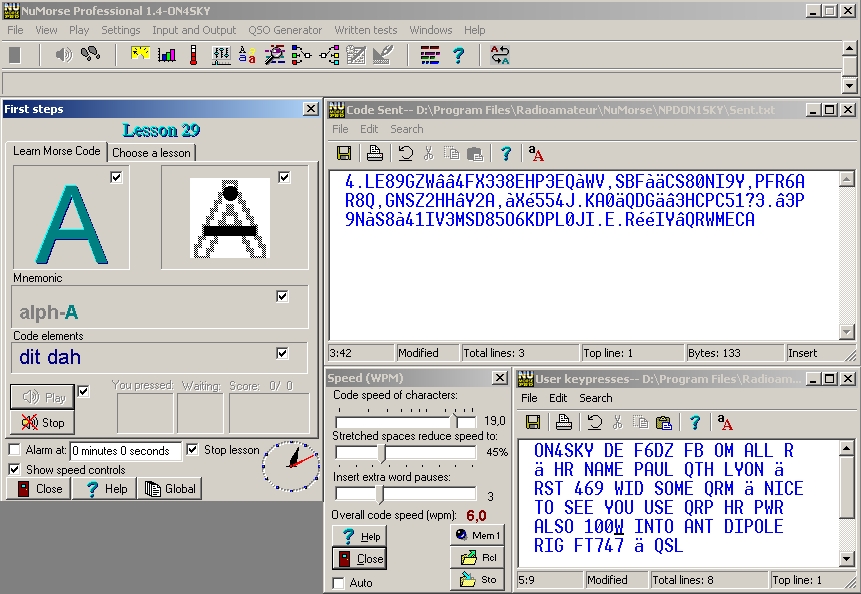
NuMorse
Pro This
is very a complete and powerful utility to learn Morse code based on
the famous Ludwig Koch's method (1930s). The speed can be set up to
50 WPM. NuMorse requires a registration. The sound per session is time limited
by a counter. After some weeks, this feature is disabled if you
don't buy the license. NuMorse
provides several windows displaying the concerned character to
display, its mnemonic image, the list of characters sent, and in
option additional windows showing the speed of the lesson, your
score and other settings. All
the interest of NuMorse Pro is in its "First step" feature that helps you learning the Morse code progressively, at a
rate that you fix yourself, beginning with easy letters like E, A,
N, to end with
the punctuation and other more complex prosigns. The second
advantage, it can read external text files containing for example
the text transmitted during a real QSO. An
advice : as soon as the first lesson, begin to set the speed at 5
WPM, not slower (selecting a code speed of characters of 13 WPM for
example and stretching space between characters of 54%). You will
see that it is not difficult to understand characters, all the less
that they are regularly repeated in the respect of Koch's method. In
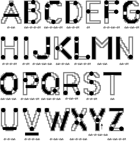
addition, I suggest you to replace all mnemonic images with their CW
representation as displayed at left (in the original version for
example "A" sounding like "dit-dah" it displays
the phrase "A jar" with the image of a jar). I have found
that mixing the outlined letter with its code representation inside
speeds up and improves learning. Here is a poster showing all
mnemonic letters. If you want to test this method,
here is a zip file containing 31
individual files created in bitmap format to copy in the "\NuMorseSource
File" subdirectory (move or rename first the original files). I
make the bet that using NuMorse Pro, working only 15 minutes each
day, in one month you know the Morse code, a first step to get your
full privilege license or to seriously work DX stations in the CW
segment of HF bands. NuMorse
professional runs on all Windows 32-bit platforms equipped with a
sound card. A demo is
available.
|
|
1994-2004,
Stephen C. Phillips
Freeware |
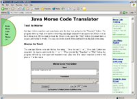
Java
Morse Translator
Stephen
C. Phillips developed this web interface to the attention of all
people interested in learning the Morse code via the Internet. You
simply type characters in the top box, separating words by "/"
or "|". When you hit the "Translate" or
"Play" button the program will process your input and
translate it into code in the lower box. If it cannot translate a
letter it will place a '*' in the output. The speed can be
set between 5 and 40 WPM.
You
need an active Internet connexion and the Java plug-in to use it.
Stephen provides also a CGI version. In his FAQ page Stephen
explains how to run his application locally on your PC by
downloading three files from his website.
|
|
2000,
Kenwood, Freeware |
TS570-RCP2
This
is a CAT program called "RCP2" released by Kenwood to
control the TS-570 series of transceivers remotely via a serial
connexion. It permits to set filters and less accessible options
from the keyboard.
RCP2
is supported by various logging and communications programs like
CommCat, DX4Win, Logger, SwissLog, or WIN/Log EQF to name a few.
Remember that
you must use a "direct" cable, not crossed, to address the
VFO and memory channels with this program.
RCP2
software runs on all Windows 32-bit platforms.
|
|

1993-2004,
F1EHN
Freeware |
EME
by F1EHN
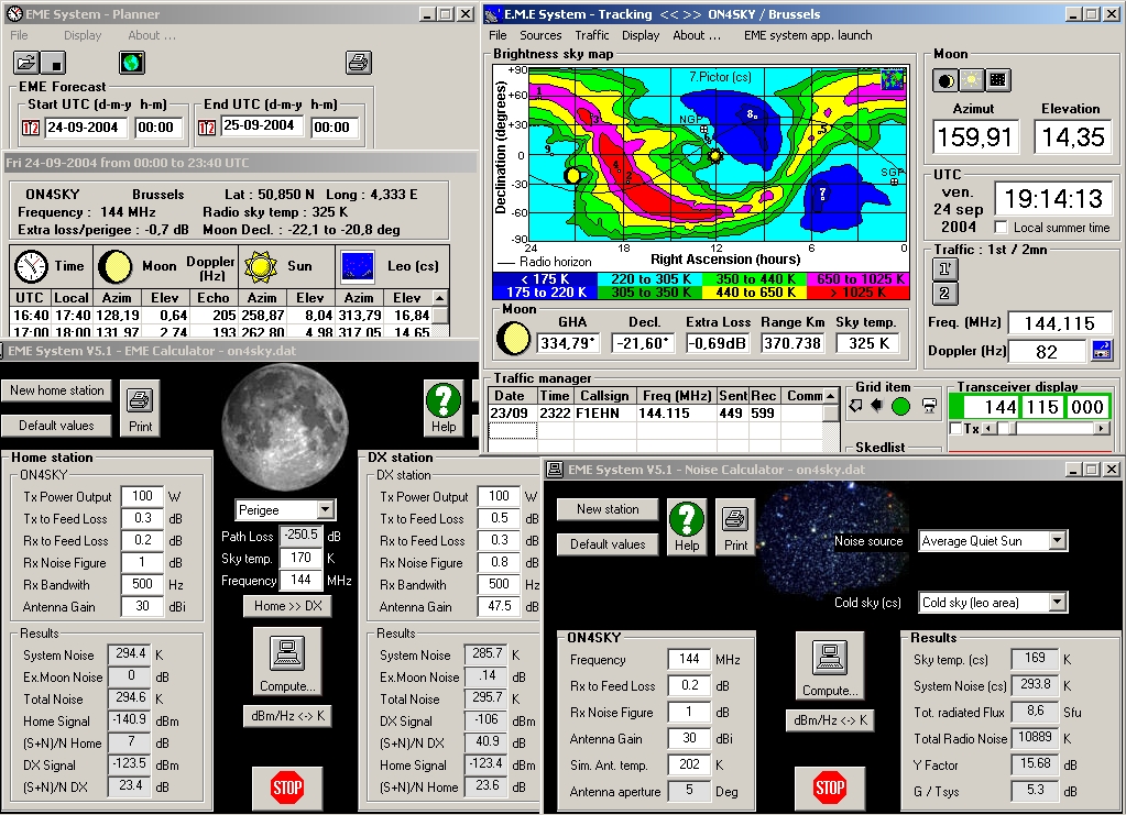
F1EHN's
EME
is a set of applications that permit to plan an EME contact in
gathering all information about performances of your system and
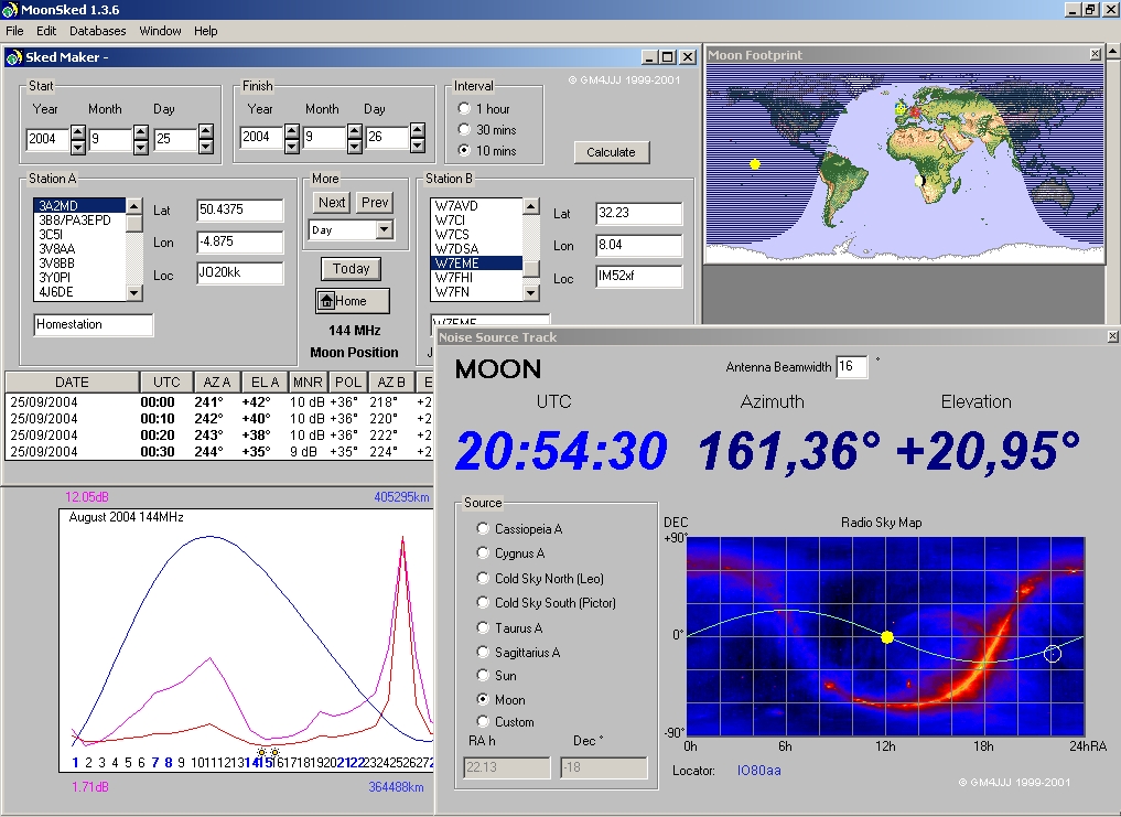
astronomical ephemerides. It works in the same way as GM4JJJ's
MoonSked (not reviewed because the demo comes with a 5 minutes
timeout only...) but provides some additional data about RX and TX
signals. In addition it can drive your antenna and
receiver and comes with a small traffic manager (logger). It is used
by more than 180 EME enthousiatics in 27 countries.
You
must first run "emesetup" to set your QTH, transmit power, working
conditions and save the information in a data file that will be
shared with the other modules. Then you must select each of the four
stand-alone applications (EME calculator, noise calculator, planner
and tracking) to calculate the system noise at home station or DX
station (in K or dBm), signal strength, S/N ratio. Thanks to the
planner, EME displays also a table listing all tracking parameters
(azimuth, elevation, doppler, etc) at 20 minutes intervals for 24
hours. The tracking utility displays either a world map showing the
target location or a sky map in false color showing noise figures of
most important radiosources (Milky Way, Cygnus-A, etc). These data
take into account the time of the day, working frequency, and
antenna properties (beamwidth, output power, gain, etc). At last F1EHN
provides an interface board to drive your antenna.
If
the tracking window is the most important and gathers all important
information (DX coordinates and distance, moon azimuth and
elevation, time, frequency, doppler, spatial polarization offset,
etc), I
regret only that all modules have not been integrated into a same
interface using a main menu subdivided in as many submenus that
there are applications. All interfaces as well as the manual (1.3 MB
in PDF) are written in English to ensure to the product an
international
The
new version 5.x adds a "moon data" window plotting the
moon elevation during the next 30 days, it includes as new automatic
antenna diagram measurement, an improvement on EME calculator and
supports Gray code output.
EME
is now at version 5.1 and runs on all Windows 32-bit platforms.
|
|
2001-2004
Sebastian
Stoff, Freeware |
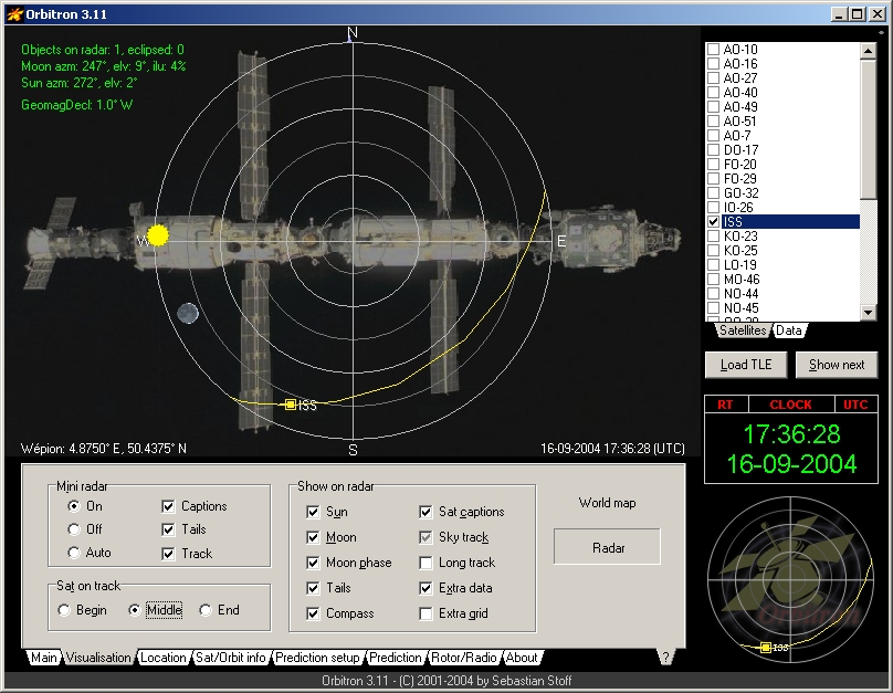
Orbitron
This
is a very complete satellite tracking program working in real-time or simulated
from any satellite 2 lines elements (TLE). Its predictions are based
on the NORAD SGP4/SDP4 model and display in theory an accuracy close to
100 ms
or 1 meter at the equator. At home and at the condition that your PC internal
clock is well synchronized with a time server, this accuracy is
within 5 km with 90% confidence interval, close to Heavens-Above's
predictions. About accuracy of models read this
thread and all next linked.
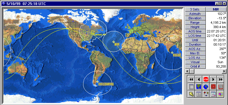
Orbitron
supports several resolution from VGA to full-screen in high
resolution. It provides two main screens, a world map with a small
radar window below right with, and a radar map that enlarges the
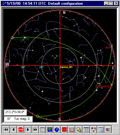
small radar map displayed below right. It displays in real time the path of the satellite through the
sky and its current position when it is above your local horizon. But there is no reference
to stars. A forecoming add-on called "Sky View"
should correct this. Like
other products showing points of the compass, to use properly the
radar, it must be oriented to the North so that the West points to
the left and the East to the right. You cannot place the map
overhead looking to the southern meridian for example, as we do in
astronomy, because East and West will be inverted.
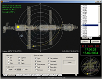
A
third window displayed above right list all satellites (loaded as
TLE text files) and current parameters of any selected satellite.
You can select as many satellites as you want and request
simultaneously their predictions on screen or on printer.
In
addition, several configuration panels and additional information
about satellites can be displayed in
the lower part of the screen showing either settings, parameters to visualize
(sun, moon, track, footprint, identification, etc), predictions
for the current satellite and month, and even many usefull data
related the current satellite, crew and working frequencies. Other
settings are also accessible using the shortcut Alt-F5.
All
maps are dynamic and you can easily go back and forward in time to
check at for example at what time the specified satellite will be visible.
Among
custom features, you can select a night vision (that applies to all
your desktop), display the gray line, track
the sun, the moon or the satellite, set the magnitude threshold, be
alerted when there is passage over your location, predict iridium flares, and more.
Orbitron
is also able to drive an antenna rotator or a transceiver (a
receiver) using either a
built-in DDE engine (MyDDE, SpidAlfa, WiSPDDE client) or an user
interface based on the Delphi source code provided by the author.
WiSP DDE is the most complete interface and supports without
problem a lot of hardware.
When satellite mode is selected,
this submenu provides in addition the doppler
shift according the up and downlink frequencies.
Data
files updates are ensured via the Internet. You have also a choice
of world-wide time servers. At last the author
provides several world maps in BMP format, the coloured hires one being the most detailled. At last among
its other originalities, Orbitron supports over 17 foreign languages, custom image
and as many TLE files as you want.
Orbitron
is a freeware. Sebastian ask you only to send him a post card of
your location. Bargain ! The
program runs on all Windows 32-bit platforms and Linux with Wine. A
version 4 is under development, including a 3D viewport, a faster
pass prediction engine, new world map engine, and lot of new
features for radio amateurs and observers.
|
|


(c)
1996-2004
Northern Lights
Software Ass., $60
Freeware
since 2017 |
Nova
for Windows
This
is an excellent and cheap satellite tracking program, very accurate,
complete, well designed and very appreciated, including at NASA or
USAF, to name some majors users. It will be very useful to all operators who need to
track satellites or drive their antenna on
communications or weather satellites. Nova is
able to track - in real-time or simulated - on any satellite knowing
its 2 lines elements (TLE), even space probes launched at
destination of the outer space if you know their geocentric RA/Dec.
In that case you have to enter their coordinates as
"extra" satellite.
For
global predictions Nova uses a Plan-13 algorithm which is a
simplified version of SGP4. This last employs general perturbation
theory to provide highly accurate prediction of orbital positions.
As the NORAD SGP4/SDP4 algorithm is more time-consuming it should be use only if high
accuracy is needed. In the best-cases, using up-to-date Keplerian
elements and the SGP4/SDP4 algorithm the accuracy is about 0.1° or
11 km, not very good by astronomical standards but well enough to
aim any antenna or scope.
Nova
provides various high resolution and colorful views with zoom
possibilities : a rectangular map and a space view derived from NOAA
4-km AVHRR land-sea data (~10 km/pixel), an elevation contour, a
radar map (in front of stars) and a static sky noise map at 50, 130
and 400 MHz. Utilities include an scripting screen to automatically
manage multiple passes of several satellites, an experimental mode
for examining the effects of changes in TLE on satellite orbits, a
derived function to examine values such as apogee, perigee,
altitude, period, etc, the mutual visibility of two satellites and
more.
You
can also customize your horizon, telling the program that such
azimut is closed up to 30° high for example.
Except
some planetarium software reviewed on
this site, this is one of the few satellite tracking
software to display the path of satellites in front of the starry
sky (view at zenith), a convenient way to wait for their pass near a
bright star and why not to picture their trail, this time well
framed... To use properly the map, it must be oriented to the North
so that points of the compass are at the right place : the West
pointing to the left and the East to the right.
For such occasions, at the request of some amateurs
astronomers, a RA/Dec readout of mouse location was added to the
radar map. In the same ordre of idea, today Nova supports
the Meade LX-200 and ETX telescopes, for those who want to visually
observe satellites.
However
Nova is not able yet to answer the question "what is this satellite
crossing near Vega ?" for example, except displaying all
satellite trajectories on screen. According to NLSA this kind of
features will be included in a forecoming product named Orbital
Mechanic.
Good
news, since end 2017 "Nova for Windows" is available free
of charge (the registration code is NLD-8554457).
Nova runs on
all Windows platforms but Windows 10.
|
|

1998, Amsat, Freeware |
WinOrbit
This
is an excellent freeware devoted to satellite tracking. It provides
four major functions: a graphical display of satellite
positions in real time, simulate or manual modes, a tabular display
of satellite information, ephemerides for planning or analysis
future satellite orbits and the possibility to output the data (az,
el, doppler, etc) to control the tracking of antennas, radios or
telescopes.
From
your regional parameters (QTH) and date of year WinOrbit simulates
or display in real-time up to 20 satellite positions (including data
from external sources you can add and save) with a zoom factor from
1 to 4, including an Earth view from the satellite. All calculation
are done in double precision (14 significant figures) giving a
epoch-time precision of about 100 microseconds, or a position
precision of about 1 meter. There is however a limitation by the way
WinOrbit manages the Windows date conversion routine. According the
author this implies a possible (apparent) position error of up to 8
km at the nominal time depending of the reference epoch time and the
actual time of calculation.
Using
the SGP4 algorithm and the highest resolution, the product is
time-consuming when we select the continous update, even on Pentium
III processors. The bitmap resolution is better than about 0.3
degrees (about 33 km at the equator) but small islands, estuaries
and lakes have been omitted in many cases.
First
published in Orbit magazine by Tom Clark (W3IWI) in 1981, the
program runs today on Windows 3.1 but runs fine on OS/2, Windows 95
and NT with a resolution up to SVGA in 256 colors. Bugs revealed by
advanced users are listed in a text file. Satellite TLE's are
available from many Internet sources (see my Artificial
satellites page for details, in French). Note that Sat-net
website is no more updated.
|
Back
to Amateur radio activities
Back
to Reports & Comments
|


