|
Satellites reception
|
|
|
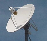
METEOSAT satellite dish. |
Reception
of weather images (II)
Let's
take the ideal case where you have a directional antenna fixed on a small rotator.
Once the hardware part installed you must install a satellite tracking software
like WXTrack
that supports the UNI-TRAC
or the old Kansas City Tracker interface.
Among software name Orbitron (screenshot)
and Nova for Windows (screenshot)
as well as astrophotography software FireCapture
(screenshot) and Stellarium
(screenshot) able to manage the
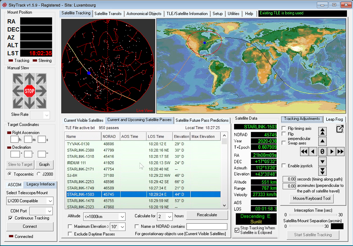
mount of scopes and CCD cameras. Among licenced software name SkyTrack (screenshot).
All them require the last Keplerian data
file or TLE describing satellites orbital parameters.
When
the various modules are connected, powered, and their status checked,
you can chase the satellite of your
choice. Even if your antenna is not directional you need of a tracking
software to locate the satellite in real-time. In this case of course your
computer is not linked to your antenna, and it simply simulate a real-time
tracking.
Signals
that you can collect are numerous : from telemetric data (satellite temperature,
orientation, current, etc) transmitted in AX.25 mode (packet), to digital encrypted
images or analog signals transmitted in clear in SSB, SSTV, AM or FM mode
or in dedicated modes like APT and WEFAX in the case of weather satellites.
A low orbit satellite crosses the sky in about 10 to 15 minutes, quite
rapidly. So it is prudent to prepare your manipulations in advance because
if you miss a passage you 'd have to wait at least 1 hour to make a new attempt.
Hopefuly, today tracking software and decoders make the job easier, and it is often
sufficient to depress a button to start an acquisition process, the
storage of images being automatically handle by some applications.
Weather
satellites reception
Weather
satellites transmit their data continuously on several frequencies, in
various transmission modes and resolutions. There are four main
transmission modes :
-
APT used by polar orbit satellites, WEFAX and HRI (PDUS)
used by geostationary satellites
-
MSG used by METEOSAT of the second generation.
-
We must add modes more difficult to decode like HRPT or CHRPT that require
more sophisticated equipements.
The
two main modes are APT and WEFAX. Their differences are the
modulation mode, respectively FM and AM, the rate of transmission of 120
lines/minute (lpm) vs. 240 lpm and the Index of Co-operation (IOC) of
576 vs. 267.
-
APT mode : APT
stands for Automatic Picture Transmission. This is the oldest and the
simplest FAX transmission mode by satellite. It enables a fully automated and unattended reception of
weather pictures based on special start and stop tones recognized by the
decoder.
|
|
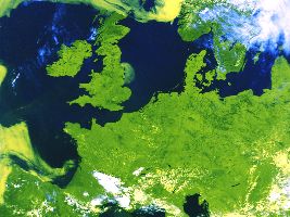
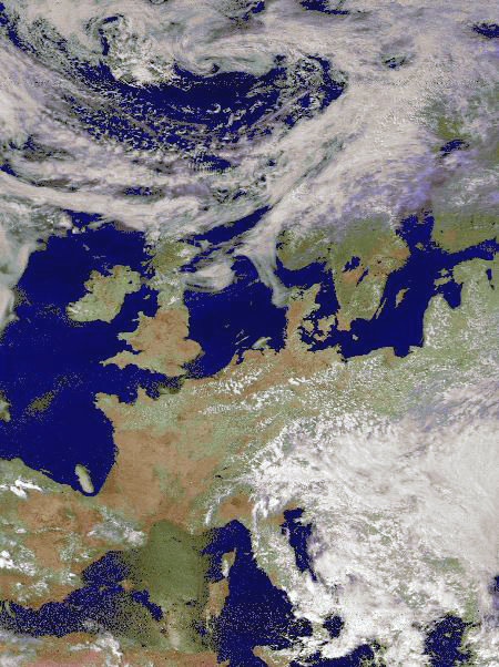
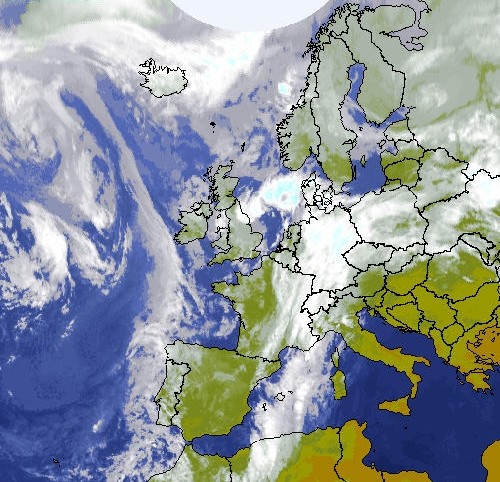
Picture
of Europe transmitted in APT mode by a NOAA satellite. The B/W raw
image has been postprocessed in false colors. |
APT
signals come directly from weather satellites in polar orbit (NOAA
12 and 15 on 136.50 MHz, NOAA 14 on 137.62 MHz, NOAA 15 on 137.5 MHz,
METEOR 3 on 137.85 MHz, etc) without intermediate processing by ground
stations. These later upload software corrections, put
the satellite on or off, etc but don't change the images content.
APT
signals are transmitted on 137 MHz. This band is easily accessible
on low cost receivers at the condition to use an IF
FM Filter offering a 30 to 50 kHz bandwidth. Indeed,
many all-band receivers and scanners come with either a too narrow (15
kHz) or too wide FM filter (230 kHz).
Many
multi-mode decoding software also support
this mode of transmission. Most of these satellites pass twice over the
same region in 24 hours, and almost always at the same time, once from
North to South and once from South to North direction.
The
APT signal includes a synchronisation pulse in raster lines
(called telemetry) that is scanned from Earth, this is the information
displayed on the left and right of each picture.
The
APT signal is easily recognizable to it modulated frequency (FM) and
carrier tonality ranging between 1500-2500 Hz. New satellites have a 2400
Hz carrier like this NOAA 14 APT signal.
In
APT mode, satellites transmit at the rate of 120 lpm alternating two channels, one for the visible image,
the other for the infrared image. This is through the decoding software
that you select one or another channel.
The resolution is 4 km/pixel.
Images are recorded in gray scale but software like WXSAT or SIAMIV can process them in false colors.
Russian
weather satellites only transmit infrared images at 120 lpm. The sound
of their transmission is thus slightly different from the other
weather satellites like on this record of a RESURS
01-N4 signal with an IOC of 382. On their side, METEOR 3-05
uses a higher carrier closer to 2500 Hz with an IOC of 382 as well.
-
WEFAX and HRI mode : WEFAX stands for Weather Facsimile.
Like APT, images start and stop with tones as for faxes transmitted on
shortwaves (SW FAX or HFFAX). WEFAX is today supported by most polar
and geostationary satellites. It uses the standard voice audio
channel with an AM carrier at 2400 Hz modulated with a 1.6 kHz
video signal.
|
|
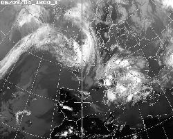
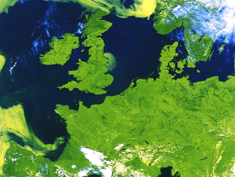
|
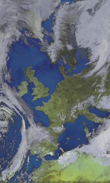
Europe
and Maghreb pictured by METEOSAT 7 on June 3, 2004 at 18h TU. |
Normally
charts on HFFAX are B/W, reason for which a decoding on 2-bit depth is
enough. METEOSAT on the contrary transmits its images in gray scale, at
the rate of 240 lpm alternating visible and infrared scans. Each tone
corresponds to a specific shade of gray encoded while the satellite
observes the Earth. Start tones for METEOSAT are modulated at 300 Hz (same as HFFAX) and
also includes some chart info (like telemetry data). The stop tone is
at 450 Hz, the same as HFFAX, and there are at last horizontal
synchronisation bursts for each raster line easily recognizable to
their "tick-tock".
These
synchronization pulses begin with the visible scan with a burst of 1040 Hz
(the "tick"), followed by the IR scan burst at 832 Hz (the
"tock").
Due to this special periodical modulation, the composite audio signal shows a
very recognizable FM tone onto 1691.0 MHz (channel A1) and 1694.5 MHz
(channel A2) carriers.
A
satellite like METEOSAT transmits its pictures every half-hour to ground
tracking stations. These raw data are reformatted in real time, engineers
add political boundaries and label each image, then transmit the corrected
image back to the satellite where it is retransmitted again to the Earth
at 1.691 GHz to the attention of all users. At
receive, WEFAX images are cut into 800x800 pixel sections and annotated. A
line of 800 pixels is transmitted in 250 ms, hence a complete picture is
constructed in 3m33s. WEFAX
signals are transmitted by METEOSAT, GOES, INSAT, GOMS geostationary satellites,
each of them covering a dedicated sector of the world (for example, METEOSAT 8
covers Europe and Africa, METEOSAT 5 and INSAT cover Indian ocean, GOMS
covers Russia, GMS covers Far East, and GOES covers America).
Like
EUMETSAT birds, all these satellites transmit two types of images : WEFAX (analog
mode) and HRI or PDUS (High Resolution digital Images, encrypted). WEFAX
images are the easiest to record. If you don't have a satellite dish tuned
on 1.69 GHz (similar to a TV dish of at least 1m in diameter), you can use a
SHF Yagi, a quadrifilar helix or even a GPS antenna called "micropatch
flat antenna" 22.5 cm (9") long. In all cases your antenna
must be connected to a 1690/137 MHz downconverter (see below) or directly
to a WEFAX decoder as we explained previously.
To
read : Web-based
signal decoder for NOAA weather satellites, RTL-SDR, 2022
|

|
 |
|
|
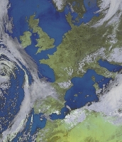
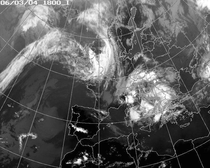
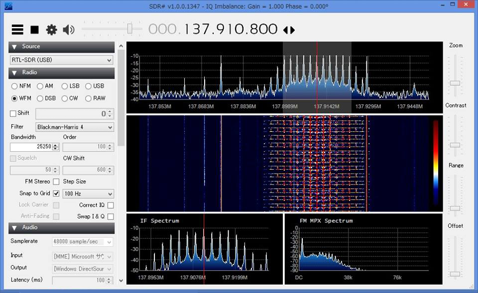
Surrounding
the MSG-1 satellite, alias METEOSAT 8, two WEFAX images
recorded on 137 MHz and respectively transmitted in
analog and ADTPEC mode by
NOAA 14 satellite. |
|
-
MSG mode : the geostationary MSG-1 satellite, alias
METEOSAT-8 is operational since the end 2002 and remplaces METEOSAT 7
at the longitude of 0°. It transmits images in low and high resolution (LRIT
and HRIT) in C-band between 3.7 and 4.2 GHz.
- HRPT and CHRPT modes : these are two high
resolution transmission modes used by satellites in polar orbit
transmitting on the frequency of 1.69 GHz. Due to a multispectral analyze occupying
between 5 and 10 channels, the resolution reaches 1.1 km/pixel but images
use up to 120 MB of disk space. To reserve to experts.
Some brands like Timestep provides
the require digital hardware to decode LRIT, HRIT, HRPT and CHRPT
modes.
The receiver
As
listener (SWL), to receive APT signals from weather
satellites between 136-138 MHz - the easier way to begin - you can buy a radio
receiver covering VHF bands equipped with the appropriate IF filter to get a 30-50 kHz bandwidth.
You can find on the second-hand market receivers at a few hundreds euros.
Easier
to handle and sometimes cheaper, for some decades there are receivers
covering all the spectrum. There are first scanners that are all bands and
all modes receivers. The ideal is to find a model offering a bandwidth suited to
APT signal (about 30 kHz). Very few satisfy to this requirement. Among the
base models, there are AOR
5000 (10 kHz-3 GHz, 1900 €) and AOR
5001 (40 kHz-3.15 GHz, about 4500 €).
In
the digital age, a very appreciated solution by amateurs because very
complete and compact is the Software-Defined Radio, aka the SDR system.
Among these SDR solutions name RTL-SDR, SDRPlay,
AirSpy HF Plus, DX Patrol, HackRF,
SDR
Sharp (which software is
free) as well as Orbitron if you
already own a receiver. Some interfaces
are not larger than a USB stick like the Funcube
dongle.
To
join : APT Group on Facebook
To
read: Receiving
NOAA Weather Satellite Images, RTL-SDR
You
can also purchase an external receiver for computer like the old box ICOM PCR-1000
(100 kHz-1.3 GHz, $629) and its successors (PCR1000-02, PCR1500-30 and PCR2500)
but which production is discontinued, the external receiver WinRADIO
WR-G31DCC "Excalibur" (9 kHz-50 MHz, $850) or the much more
expensive WinRADIO card WR-3500i DSP (150 kHz-2.6 GHz , $2495) or WR-3700i DSP
(150 kHz-4 GHz, $2995 ) offering a wide coverage.
Remember
that if you can use freely a all-band receiver, listening to some reserved
frequencies (military among others) is prohibited if you cannot proved a
professional interest in using these bands.
For
the amateur radio, thus licensed
and authorized to transmit on ham bands, there is no all modes transceiver
covering all frequencies between 150 kHz and 4 GHz. However, he can
use a desktop or portable transceiver covering HF bands to UHF (e.g.
ICOM IC-7000, IC-9100, Kenwood TS-2000, Yaesu FT-100, FT-857D, FT-991,
etc), although most amateurs dismiss this solution as a possible defect
will immobilize the rig and prevent any traffic on all bands during several weeks.
The alternative is to use a classic HF transceiver and add it the appropriate
VHF or UHF converter.
That
said, most amateurs prefer to purchase several transceivers, each being dedicated
to some bands, in order to cover all the spectrum from LW or HF bands to UHF and
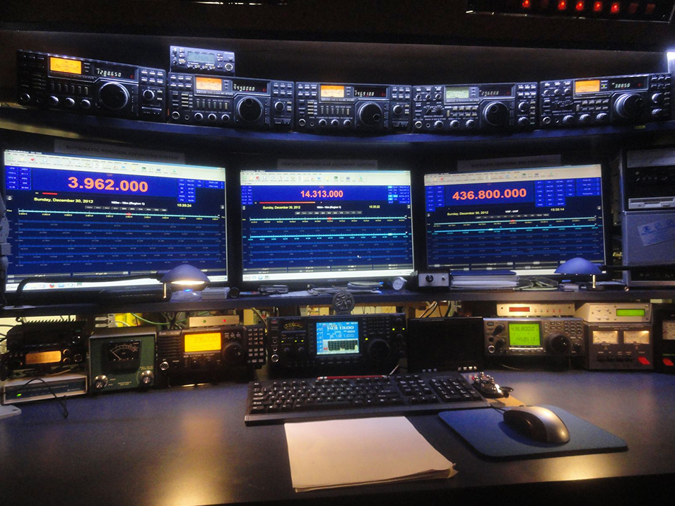
higher if needed (see this ham shack). The amateur can
begin with a portable transceiver like Yaesu FT-2800M
or with the more recent model FT-1900R or FT-2900R covering the 2-m
band in emission and from 137 to 174 MHz in receive.
Of course,
whatever the solution, these systems need to be connected to
an antenna tuned on the specific working frequency and the interface must
be completed with a decoding program to vizualize weather images like WXtoImg
or HRPT Reader. If
you use a SDR system, you also need a mean to transfer the audio to
the decoding software. There is the virtual
audio cable, a small tool allowing to exchange very easily audio
flows between applications without having to use the speaker, the
microphone or a intermediate converter. Another program is VB-Audio
Software.
To watch : How to take NOAA satellite pictures using RTL-SDR for under 50$
Receiving
NOAA weather satellite using SDR# and WXtoImg
WR-G31DDC 'EXCALIBUR' Demonstration Videos, WinRADIO
9 kHz to 50 MHz Digital Receiver
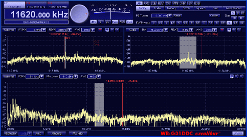 |
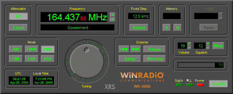
|
Above,
the graphic user interface of the WinRADIO
WR-G31DDC "Excalibur" running on a PC. This interface is
combined with an external receiver covering in continuous from 9 kHz to 50 MHz. Below, the
GUI of the WinRADIO WR-3000i card tuned on VHF aviation bands.
Its frequency range is 150 kHz to 1500 MHz in AM and SSB. |
 |
|
About
the antenna, you can use a fixed antenna like a discone or quadrifilar helix that works fine even
when the satellite is only 20° above the horizon. If you use
a directional antenna, the ideal is to use a rotator but considering the
required precision and its weight, this motor will be
often the most expensive part of your installation (300-1500€).
Simpler and cheaper, you can also set up a small home-made crossed-dipole
cut for the 136-138 MHz band.
To
receive WEFAX on 1.69 GHz you can use your APT receiver and add in a
downconverter 1690/137 MHz, but often received images display a poor
quality and resolution. To improve your images you can buy a WEFAX
receiver like the model sold by Timestep
or a SDR interface including UHF bands.
At
last, for your information, to receive Inmarsat
at 1.5 GHz, besides SDR or WinRadio cars and scanners (cf. this video),the most
robust and efficient solution is to use a dedicated receiver like Miteq
Inmarsat Pilot or a competitor. This prevent you to buy or to
build a downconverter and the signal will be of excellent quality. This
receiver uses digital techniques (DSP) as well as a frequency
synthesizer. It is compatible with most maritime and aeronautical
applications.

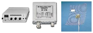
Downconverter
and demodulator
Only geostationary satellites like METEOSAT transmit on high frequencies and in digital
modes. Instead of acquiring a specific receiver for the 1.69 GHz band or a WinRADIO card quite expensive with
its FAX module (at least $600), you can use a 136-138 MHz receiver,
the one you use to receive transmissions from polar satellites (NOAA, METEOR, RESUR, SICH,
OKEAN). Note however that most METEOR and all RESUR, SICH and
OKEAN are not active in APT mode.
You only need to equip
your VHF receiver with a 1690/137 MHz downconverter like the TV970
displayed below offering a 30 kHz bandwidth.. This converter must be placed directly
below the dish (if the dish is wide enough it can be placed in the
feedhorn too) because at so high frequencies signal losses are significant.
Your installation must be completed with an Analog-to-Digital (A/D) converter
to demodulate signals that you will connect to the serial port of your
computer.
Today this A/D adapter is replaced by the sound card
built-in in any computer (same principle as for SSTV) or you can build or
buy an external device like MFJ-1213
adapter or the ones sold by Bonito Communication Technologies.
|
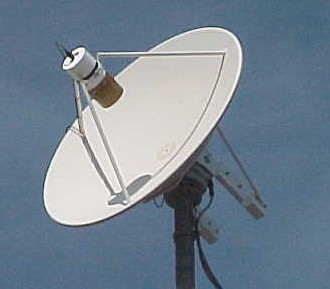
|
|
Above, a basic satellite reception
system sold by Comelec
: this solution listed at 450 € includes an analog weather receiver,
a 1690-137 MHz downconverter and a grid dish offering a 24
dBi gain. Of course there are configurations ten times more expensive
depending on performances of your receiver and antenna
systems. Below, if you are only interested in receiving weather
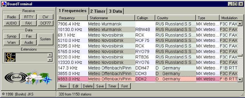
messages, here is a dump extracted from
"ProMeteo" sold by Bonito
Communication Technologies with his interface
"BoardTerminal '98". This tool allows you to
select radio frequencies of weather centers transmitting
messages like SYNOP, telex and other faxes and to display
datas in a readable format on your PC. |
|

|
|
Then,
in a classic configuration (all excepted WinRADIO) to read weather images you need to install a
decoding software able to read APT, WEFAX and other WX modes. Among free programs let's highlight
WXSAT and JVComm32/JVFax.
A very performing multi-mode decoder, but commercial is Skysweeper Pro,
that I reviewed shortly.
The famous AMSAT
website, HF-FAX as the one of Dave Ransom
provide a long list of products too.
At last, to be complete I remind you that is you are only
interested in weather data, you can receive them for free using the APRS network,
which is sometimes relayed by repeaters.
The future
METEOSAT
ended the analog transmission end 2005, when MSG
(METEOSAT Second Generation) satellites were available. The same will happen with the GOES satellites.
In all these satellites, digital receivers are used for demodulation of PSK,
BPSK, and QPSK signals. Some receivers include an optional internal frame
formatter able to support standard products like MSG HRIT, MSG LRIT, MTSAT
LRIT, NOAA HRPT, GOES GVAR, M-22 AMB, GMS S-VISSR, DOD DMSP, Fengyun 1 CHRPT, and Fengyung 2 S-VISSR.
LRIT/HRIT systems
receive, archive, display and process digital LRIT and HRIT data from EUMETCast,
MSG direct broadcast, GOES and MTSAT. Note that to receive EUMETCast and MSG direct broadcast,
EUMETSAT recommends using of a DVB Receiver
TechniSat SkyStar to DVB receiver. This device is available as an internal PCI
card or an external USB unit. It is supplied with required software (drivers and T-Systems Business TV-IP).
Some LRIT receiver will accept either 137.5 MHz or 70 MHz input, but you could
always use a down convertor 1690/137 MHz as currently.
|

|
|
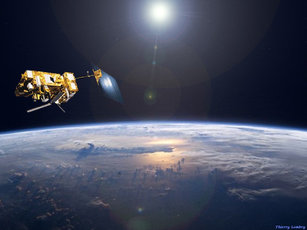
MetOp in low orbit over Earth. Doc T.Lombry |
LRIT and HRIT data
are used in more and more fields : nowcasting, numerical weather prediction,
climate monitoring, research... The latest MSG HRIT imagery is available every 15 minutes – twice
faster than WEFAX and HRI systems. Coupled with the high quality and wide range of data available, this technology
will allow major improvements in the forecasting of severe weather.
The polar orbiter from
NOAA will be available in the next years. The first converged
NPOESS satellite was available in 2008, the others depending on when the remaining POES and DMSP
(military) program satellite assets will be exhausted. NPOESS provides
significantly improved operational capabilities and benefits to satisfy the
U.S.A.'s critical civil and national security requirements for space based,
remotely sensed environmental data.
MetOp is the European
first polar-orbiting satellites dedicated to operational meteorology. It represents
the European contribution (ESA) to a new cooperative venture with
NASA providing data that will be used to monitor our climate and
improve weather forecasting.
MetOp is a series of
three satellites that will be launched sequentially from 2005 over a period of
14 years. They will constitute the space segment of EUMETSAT's Polar System (EPS).
They will orbit close to 830 km of altitude. MetOp seem
programmed to send digital transmissions as well.
The
price of the installation
The minimum
investment for a satellite receive installation is hard to evaluate because many factors
affect the price : your taste for digital and computers, for manual works, your skills in electronics,
your current equipment (you probably own a computer, maybe a SDR receiver
or a VHF receiver too), and the type of émission that you wish to decode.
The receiver
or the dedicated decoder, and the suitable antenna represent certainly the two
most important expenditure of your installation. If a second-hand VHF receiver
can easily be found in advertisements for a price between a few tens and a few
hundred euros, in the best case the helix or the dish antenna will be sold
at the same price as the receiver, all the more if you add it a rotator and
install it on a mast or a heavy-duty steerable mount, hence the interest to built
it oneself.
Globally,
that you use a VHF transceiver or a SDR receiver, let's say that you must count on an investment of about
450 € minimum, the computer in addition (see above the material sold by Comelec). Of course there is no maximum price.
Timestep provides all the required hardware for prices ranging between 1000-3000 €.
Using
such installations you can't miss any more the next crossing of Nimbus satellite and consorts.
Good
hunting and... good receive !
Riddles
in the Sky, Scott Tilley, VE7TIL
Build
Your Own Satellite Ground Station, Makezine
An
Introduction to Amateur Satellites, W0ECC (PDF on AMSAT website)
Monitoring NASA
communications (frequency list)
Klingenfuss'
Super Frequency List (Broadcasting and utility frequency list on
CD-ROM) Interferences
receiving APT/WEFAX images (EUMETSAT).
RTL-SDR
Tutorial: Receiving and decoding data from the Outernet, RTL-SDR
Antenna
: MegaLoop ML200,
MegaLoop FX, Quadrifilar Helix Antennas (Gogan.org),
Seavey Antenna, Diamond MR-77 avec connecteur PL, Tram
1185 bi-bande, Thiecom, Timestep
Coaxial
cable : RF
coaxial cable (M/F SMA to SO-239 to link a doggle to a whip antenna)
Microwaves
: UHF-Satcom, Amateur
DSN Group (Yahoo!)
DSP software:
FFTDSP, Skysweeper Pro, Spectrum
Laboratory, Spectran, Spectrogram,
Raven, Adobe
Audition, MatLab
Multi-mode
decoders: Skysweeper Pro, Spectrum
Laboratory, WXSAT,
JVComm32/JVFax,
WinSat Pro, Wavecom
Satellite tracking
software (licence): Satellite
related Software (AMSAT), Nova for Windows
SDR
interfaces and software : Funcube, RTL-SDR,
SDRPlay, AirSpy
HF Plus, DX Patrol, SDR Sharp, HackRF,
SDR
receivers on Amazon : RTL2832U+R820T,
48-863 MHz, RTL
R820T+8232, 100 kHz-1.7 GHz
Weather
balloon monitoring : SondeMonitor
Software
for satellite tracking (licence) : Satellite
related software (AMSAT), SkyTrack
Software
for satellite tracking (freeware and shareware) : Satellite
related software (AMSAT), Stoff, KF2BD,
N1VTN, Pocketsatplus,
ZL3AD, SatScape,
WXSAT, WXTrack,
Orbitron, Nova for Windows,
GoogleSat Trak,
Real Time Position of Amateur Satellites over Europe,
AMSAT Pass Prediction Calculator, Heavens-Above,
Spaceweather, FireCapture,
Stellarium
Tutorial
: RTL-SDR,
Planetary.org
Virtual
Audio Cabling: VB-Audio
Software, Virtual
Audio Cable
Weather
hardware: MScan, Qurom, Comelec,
Bonito Communication Technologies, Seavey
Antenna, Timestep
Weather
image decoder: WXSAT,
SIAMIV, DARTCOM,
WXtoImg, HRPT
Reader
TLE
and predictions : Real Time
Satellite Tracking and Prediction, 3-line
TLE (CelesTrak), ISS
Latest TLE, Satellite
Tracking
Back
to Menu
|


